Lalitpur District, Nepal
| Lalitpur ललितपुर जिल्ला | |
|---|---|
| District | |
 | |
| Country | Nepal |
| Region | Central (Madhyamanchal) |
| Zone | Bagmati |
| Headquarters | Patan |
| Area | |
| • Total | 385 km2 (149 sq mi) |
| Population (2001) | |
| • Total | 337,785 |
| • Density | 880/km2 (2,300/sq mi) |
| Time zone | NPT (UTC+5:45) |
| Website | www.ddclalitpur.gov.np |
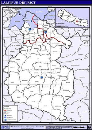
Lalitpur District (Nepali: ललितपुर जिल्ला![]() Listen , a part of Bagmati Zone, is one of the seventy-five districts of Nepal, a landlocked country of South Asia. The district, with Patan as its district headquarters, covers an area of 385 km² and has a population (2001) of 337,785. It is one of the three districts in the Kathmandu Valley, along with Kathmandu and Bhaktapur. Its population was 466,784 in the initial 2011 census tabulation.[1]
Listen , a part of Bagmati Zone, is one of the seventy-five districts of Nepal, a landlocked country of South Asia. The district, with Patan as its district headquarters, covers an area of 385 km² and has a population (2001) of 337,785. It is one of the three districts in the Kathmandu Valley, along with Kathmandu and Bhaktapur. Its population was 466,784 in the initial 2011 census tabulation.[1]
Geography and Climate
| Climate Zone[2] | Elevation Range | % of Area |
|---|---|---|
| Upper Tropical | 300 to 1,000 meters 1,000 to 3,300 ft. |
9.9% |
| Subtropical | 1,000 to 2,000 meters 3,300 to 6,600 ft. |
79.3% |
| Temperate | 2,000 to 3,000 meters 6,400 to 9,800 ft. |
10.8% |
Towns and villages
Ashrang · Badikhel · Bhardev · Bhattedanda · Bisankhunarayan · Bukhel · Bungamati · Chandanpur · Chapagaun · Chaughare · Chyasal · Dalchoki · Devichour · Dhapakhel · Ghusel · Dukuchhap · Durlung · Gimdi · Godamchaur · Godawari · Gotikhel · Guitole · Gwarko · Harisiddhi · Ikudol · Imadol · Jawalakhel · Jharuwarasi · Kaleswor · Khokana · Kupondole · Lamatar · Lele · Lubhu · Malta · Manikhel · Nallu · Pyutar · Sainbu · Sankhu · Siddhipur · Sunakothi · Satdobato · Thaiba · Thecho · Thuladurlung · Tikathali · Nakkhu
Education
Lalitpur district is Nepal's first fully literate district. Cities of Lalitpur District have adequate education facilities in comparison to other districts. Students from various districts come to study here. Some of the nation wide popular institutions are - Graded English Medium School (GEMS) - Rato Bangala school - Adarsha Bidhya Mandir (AVM) - Little Angels school - St. Xavier's School - St. Mary's School - Institute of Engineering (Pulchowk) -Little Learners Fun School [Saibu Bhaisepati]
See also
- Zones of Nepal
- Jawalkhel
References
- ↑ http://census.gov.np/images/pdf/Preliminary%20Leaflet%202011.pdf
- ↑ The Map of Potential Vegetation of Nepal - a forestry/agroecological/biodiversity classification system, . Forest & Landscape Development and Environment Series 2-2005 and CFC-TIS Document Series No.110., 2005, ISBN 87-7803-210-9, retrieved Nov 22, 2013
- Districts of Nepal at statoids.com
External links

Coordinates: 27°40′N 85°19′E / 27.667°N 85.317°E