Lake Thun
| Lake Thun Thunersee | |
|---|---|
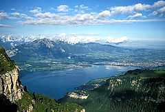 View with Thun from the Niederhorn | |
| Location | Canton of Berne |
| Coordinates | 46°41′N 7°43′E / 46.683°N 7.717°ECoordinates: 46°41′N 7°43′E / 46.683°N 7.717°E |
| Type | freshwater fjord, recent regulation[1] |
| Primary inflows |
Aare Kander |
| Primary outflows | Aare |
| Catchment area | 2,500 km² |
| Basin countries | Switzerland |
| Max. length | 17.5 km (10.9 mi) |
| Max. width | 3.5 km |
| Surface area | 48.3 km² |
| Average depth | 136 m (446 ft) |
| Max. depth | 217 m (712 ft) |
| Water volume | 6.5 km³ |
| Residence time | 684 days |
| Surface elevation | 558 m (1,831 ft) |
| Settlements | Thun, Spiez, Faulensee |
Lake Thun (German: Thunersee) is an Alpine lake in the Bernese Oberland in Switzerland. It took its name from the city of Thun, on its northern shore.
Lake Thun's approximately 2,500 km² large catchment area frequently causes local flooding after heavy rainfalls. This occurs because the river Aare (German: Aare), which drains Lake Thun, has only limited capacity to handle the excess runoff.
The lake is fed by water from Lake Brienz to the south east, which lies 6 metres higher than Lake Thun, and various streams in the Oberland, including the Kander (only since 1714). Lake Thun was created after the last glacial period. Originally and up to the tenth century, present Lake Thun and Lake Brienz were one long lake, called Wendelsee ("Lake Wendel").[2] The culminating point of the lake's drainage basin is the Finsteraarhorn at 4,274 metres above sea level.[3]
Since 1835 passenger ships have operated on the lake. There are ten passenger ships in total, operated by the local railway company BLS AG. In order to enable these ships to serve the towns of Interlaken and Thun, the Interlaken ship canal and Thun ship canal connect the lake to Interlaken West railway station and Thun railway station respectively.[4][5]
Fishing is important enough to keep a handful of professional fishers employed. In 2001 the total catch was 53,000 kg.
Following World War II and up until 1964, the Swiss Government disposed of unused munitions into Lake Thun. The quantity of munitions dumped is reported to be from 3,000 to more than 9,020 tons.[6][7]
References
- ↑ Kanton Bern, Wasser- und Energiewirtschaftsamt (Water and Energy Department): Möglichkeiten und Grenzen der Seeregulierung am Thuner See (Possibilities and limits of regulating the Thunersee)
- ↑ www.spiez.ch: Schloss (Castle of) Spiez around 1000 AD called "Goldener Hof am Wendelsee" ("Golden Court on lake Wendel)
- ↑ 1:25,000 topographic map (Map). Swisstopo. Retrieved 2014-07-28.
- ↑ "History of navigation on Lakes Thun and Brienz". BLS AG. Retrieved 2012-12-13.
- ↑ "BLS Schiffahrt - Our fleet". BLS AG. Retrieved 2012-12-13.
- ↑ Foulkes, Imogen (August 28, 2003). "Fears over dumped munitions in Lake Thun". Retrieved March 19, 2010.
- ↑ Tagliabue, John (August 12, 2009). "A Turbulent Past Lurks in a Serene Swiss Lake". NYTimes.com. Retrieved Sep 13, 2009.
External links
 Media related to Lake Thun at Wikimedia Commons
- Lake Thun Tourism Portal
- www.bve.be.ch/ bve/ de/ index/ wasser/ wasser/ downloads_publikationen.assetref/ dam/ documents/ BVE/ AWA/ de/ GWR_Reg/ GWR_hochwasserschutz_am_thunersee.pdf (German) - water regulation scheme at Thun
- Hydrological data for Lake Thun at Spiez - historic and current data: waterlevels
- Shipping pages from BLS AG web site
| ||||||||