Lake Suwa
| Lake Suwa 諏訪湖 | |
|---|---|
 Lake Suwa, Nagano prefecture | |
| Coordinates | 36°02′54″N 138°05′03″E / 36.04833°N 138.08417°ECoordinates: 36°02′54″N 138°05′03″E / 36.04833°N 138.08417°E |
| Primary inflows | 31 small rivers of the Kiso Mountains |
| Primary outflows | Tenryū River |
| Basin countries | Japan |
| Surface area | 13.3 km² |
| Average depth | 4.7 m (15 ft) |
| Max. depth | 7.2 m (24 ft) |
| Shore length1 | 15.9 km |
| Surface elevation | 759 m (2,989 ft) |
| Settlements |
Okaya Suwa Shimosuwa |
| 1 Shore length is not a well-defined measure. | |
Lake Suwa (諏訪湖 Suwa-ko) is a lake in the Kiso Mountains, in the central region of Nagano Prefecture, Japan.
Geography
The lake is the source of the Tenryū River. It ranks 24th in lake water surface area in Japan.
The cities of Suwa and Okaya, and town of Shimosuwa, are located on the shores of Lake Suwa.
Features
Lake Suwa is the site of an interesting natural phenomenon, The God's Crossing (御神渡り o-miwatari). The lake has a natural hot spring under its surface. When the lake's surface freezes in the winter, its lower waters are still circulating. This results in ice pressure ridges forming in the surface ice, reaching heights of 30 centimetres (0.98 ft) or more.
Local tradition holds that the ridges are formed by the gods crossing the lake, when travelling between the various buildings of the Shinto shrine Suwa Taisha. Folklore says it is the guardian god of Suwa, Takeminakata-no-kami, leaving his sanctuary to meet with his wife, the goddess Yasakatome, joining the opposite bank by walking on frozen water.
In fiction
- In the movie Kagemusha by Akira Kurosawa, Lord Shingen is buried in the lake.
- In Autobiography of a Geisha, Sayo Masuda tries to drown herself in the lake as a child, but hesitates because she believes a dragon inhabits it.
- In the anime Rurouni Kenshin, legend holds of an "Elixir of Immortality" that can be found somewhere in or around Lake Suwa. The main characters search for the elixir in the final season of the series and are followed by a band of evil German knights, seeking it for world domination.
- In the curtain shooter series Touhou, the goddess Suwako is a reference to Lake Suwa.
See also
- Onbashira
- List of lakes in Japan
- Kiso Mountains topics
| Wikimedia Commons has media related to Lake Suwa. |
Gallery
-
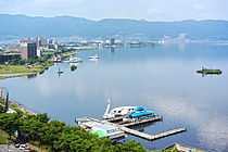
Eastern shore of Lake Suwa.
-
_-_Katsushika_Hokusai.jpg)
"A View of Mount Fuji across Lake Suwa."