Lake Saltonstall (Connecticut)
| Lake Saltonstall | |
|---|---|
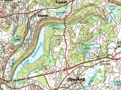 USGS topographic map: Lake Saltonstall and Saltonstall Mountain | |
| Location | Branford / East Haven, Connecticut, United States |
| Coordinates | 41°17′42″N 72°50′46″W / 41.2951°N 72.8462°WCoordinates: 41°17′42″N 72°50′46″W / 41.2951°N 72.8462°W |
| Basin countries | United States |
| Surface area | 0.66 square miles (1.7 km2) |
| Average depth | 41 feet (12 m) |
| Max. depth | 113 feet (34 m) |
Lake Saltonstall is a long narrow lake located in south-central Connecticut. It covers an area of approximately 0.66 square miles (1.7 km2) and is nestled in the center of the trap rock Saltonstall Mountain. The lake is surrounded by forest and serves as part of the local water supply for surrounding towns.
The lake and the area around it is owned by the South Central Connecticut Regional Water Authority, a company which also regulates fishing and rents boats. Private boats are not allowed.
Interstate 95 runs across the southern edge of the lake, connecting the towns of East Haven, Connecticut and Branford, Connecticut.
Lake Saltonstall's maximum depth does not exceed 113 feet (34 m) and its mean depth is 41 feet (12 m).