Lake Monger
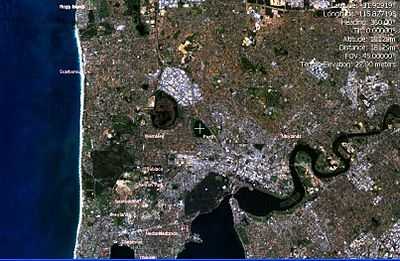
Lake Monger is a large urban wetland on the Swan Coastal Plain in suburban Perth, Western Australia nestled between the suburbs of Leederville, Wembley and Glendalough. Less than five kilometres from the city of Perth and situated alongside the Mitchell Freeway, it runs approximately north-west to south-east towards the Swan River and consists of 70 hectares of mainly open shallow water with an island of 1.3 hectares in the south-west corner. The 110 hectares of lake and the surrounding parklands are known as the Lake Monger Reserve.
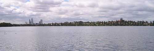
The lake is used extensively for recreation and is a major tourist attraction with up to 12,000 visitors per week (Middle, 1988). Activities include bird watching and exercise.
A 3.5 km paved walking/cycling track encircles the lake which takes about 30 minutes to traverse by foot. Ample car parking, playground equipment and barbecue facilities are also provided.
Name
The indigenous Australian Noongar people of the area called it Lake Galup, Lake Kalup or Keiermulu.
After European settlement, it became known as either Large Lake or Triangle Lake (based on its roughly triangular shape) before being named Monger's Lake in 1831. In April 1932 it was changed to its current name of Lake Monger.
Pre-European history
Little is known about the use of the lake by the Noongars prior to the British settlement other than the area was known to be within the area inhabited by those people. Given its geographical features, it could have been used regularly as a significant camping and hunting site with black swans and other wildfowl as well as turtles, frogs, gilgies and mudfish hunted as food.
Associated with the lake is the Wagyl, part of Noongar mythology. The myth describes the track of a serpent being, who in his journey towards the sea, deviates from his route and emerges from the ground which gives rise to Lake Monger.
History since 1832
Perth wetlands
The lake was originally part of a series of freshwater wetlands running north from the Swan River along the coastal plain for approximately 50 km. Lake Monger was grouped with the Georgiana Lake and Lake Sutherland (both near Mitchell Freeway, near Sutherland and Newcastle streets) and Herdsman Lake and together the area made up what was known as "The Great Lakes District".
European settlement led to many of the wetlands areas being drained for land reclamation to take advantage of the fertile soil for farming enterprises, and for expansion of parks and recreation areas. Lake Monger and Herdsman Lake are the last two major wetlands remaining close to the city. The City of Perth itself sits on an area of reclaimed wetlands. It is thought that between 49% (Riggert, 1966) and 80% (Godfrey, 1989) of the wetlands on the coastal plain have been drained, filled or cleared since 1832.
Other lakes and swamps in the immediate northern vicinity of the early Perth township were Lake Kingsford (site of the current Perth railway station), Lake Irwin (Perth Entertainment Centre) and further north were Stone's Lake (Perth Oval), Lake Poullet (First Swamp, part of what is now Birdwood Square), Lake Thomson (Mews Swamp, between Lake, Brisbane and Beaufort streets) and Lake Henderson (parts of what is now Robertson Park and Dorrien Gardens). Further north still lay Second Swamp (Bulwer Street, east of Lake Street), Third Swamp (Hyde Park) and Three Island Lake and Smith's Lake (now Charles Veryard Reserve). Many of these lakes formed a natural interconnected drainage system which found its way into the Swan River at East Perth through Claise Brook.
In 1833, water draining from Lakes Kingsford, Irwin, Sutherland and Henderson was used to drive a water-driven mill located in Mill Street.
Timeline
- In 1829, a British expedition established the Swan River Colony and in 1830, Lake Monger was the site of a minor skirmish between white settlers and a Noongar man by the name of Midgegooroo (Miller, 1980).
- By 1832, the lands around the lake had been subdivided into eight lots: a southern one was acquired by John Henry Monger and described as 200 acres [81 hectares] of Perthshire Location Ae abutting Lake Monger. William H. Leeder took up adjoining land grants at Perthshire Locations Ac and Ad, to which he later added Locations 1, Ax and Ay. This area is now known as the suburb of Leederville (Bekle, 1981).
- From 1850 to 1868, the arrival of convicts swelled the population and market gardening on the northern side of the city expanded to meet the greater demand for food. By the 1870s, "Perth was surrounded by gardens in a fan which spread from Cole’s garden in the east to Leeder’s in the west" (Stannage, 1979).
- On 9 August 1874 John Herold (54) and his stepson George Wansbrough (11) drowned when their flat-bottomed boat capsized. Herold was heard telling Wansbrough to be careful of how he moved, lest he capsize the boat, shortly before they disappeared. (The Inquirer & Commercial News 12 Aug 1874.)
- On 16 February 1876 Mary Anne Costello (a student at the Convent School) drowned while bathing on a school picnic. Another girl who was bathing with her was rescued. (The Western Australian Times 18 Feb 1876.)
- On 5 December 1876, Jemmy, an aboriginal, drowned after wading into the river to retrieve a duck he'd shot. (The Inquirer and Commercial News 6 Dec 1876.)
- In December 1894, young schoolboy Michael John Maley was found dead at the base of a tree near the lake by his brother. It was supposed he'd been birds-nest gathering, climbed the tree and lost his hold. He died from internal injuries. (Evening News [Sydney] 31 Dec 1894.)
- On 21 October 1901 Louisa Heathorn (37) and Francis George Hatch (26) both drowned whilst boating together. (Kalgoorlie Miner 22 Oct 1901.)
- In 1902, the Leederville Council appointed a board under the Parks and Reserves Act 1896 to manage the Lake (Metcalfe, 1988).
- In 1909, construction of a drain was completed which connected the lake with the Swan River and which allowed the water level to be managed (Bekle, 1981; Metcalfe, 1988). This drain still operates today.
- In 1912, the lake had an area of 111 hectares (Miller, 1980).
- On 26 May 1917 Frederick George Ribbins (7) drowned at the lake while playing with a friend. (The West Australian 2 June 1917.)
- On 19 October 1918 Wilfred Grenville Carstairs (2 and a half) drowned when he fell from a small jetty and tumbled into the water. His sister jumped in to try and save him but soon got into difficulties herself and was rescued in the nick of time. (Kalgoorlie Miner 21 Oct 1918.)
- In the 1920s, the lake and surrounding areas, mainly to the west and south were still being used as a campsite by Noongars and providing food (Metcalfe, 1988).
- On 3 April 1920 Frederick Robert Blakemore (11) drowned whilst canoeing alone. (Kalgoorlie Miner 5 April 1920.)
- From the early 1920s, the newly formed City of Perth started acquiring land which was until then being used as Chinese market gardens and dairies for conversion into public parks and recreation areas. This included land mainly around the eastern side of the lake. By 1928 the gardeners were gone and by 1930, 50 hectares of land had been bought by the Council to be developed as part of the Lake Monger Reserve (City of Perth).
- In August 1929 a newborn baby was found drowned in the lake, wrapped in two nightdresses. (The Mercury, Hobart, 27 Aug 1929.)
- After many years of delays due to lack of funds, silt dredging works commenced in May 1932 to reclaim 20 hectares of the mainly swampland (City of Perth).
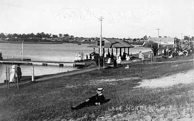
- By June 1933, 110,000 tons of silt had been pumped, allowing 4.8 hectares of land to be reclaimed. Much of the fringing vegetation was removed and replaced with lawns. The southern shore of the lake was developed with a kiosk, bathing sheds, boat house and a T-shaped jetty. A swim-through on the lake was held as part of the celebrations, as well as a canoe race involving Leederville, Wembley and Mount Hawthorn Boy Scouts and a series of bonfires. The lake was used extensively for picnicking, yachting, swimming and fishing. Some areas of the lake were further dredged to improve yachting (Miller, 1976; Metcalfe, 1988, City Planning Department, 1969).
- As well as the dredging silt, reclamation was assisted by the dumping of rubbish and raw sewage from nightsoil collectors on the north-eastern side. By 1936 the water quality had deteriorated badly and reports of nuisance chironomids (midges) were being made (Perth City Council, 1960).
- On 2 February 1937 Keith William McNamara (10) drowned when playing near the bank of the lake. It was thought he slipped from the narrow. (Kalgoorlie Miner 4 Feb 1937.)
- On 25 September 1937 Robert Edward Richards (9) drowned while playing in an improvised canoe. Efforts to retrieve his body were handicapped by the rubbish which had been dumped into the lake and by the dirtiness of the water. (The West Australian 27 Sept 1937.)
- On 27 August 1939 Reginald Frederick Rowles (16), drowned when his small canvas boat was hit by a squall and capsized. He was with Arnold Noack (16), who managed to swim partway to shore where he was rescued. (Mirror 2 Sept 1939.)
- After the drowning of Reginald Rowles, so soon after the drownings of Richards and McNamara, boating was prohibited on Lake Monger, and swimming discouraged. (The West Australian 8 October 1939.)
- Despite this, on 4 January 1946 Dorothea June 'Bubbles' Mullane (12) drowned while bathing in the lake. (The Daily News 5 Jan 1946.)
- On 3 October 1953 Laurie Bell Ball (53) drowned. It was said the deceased had been depressed at the time and there were no suspicious circumstances. (The West Australian 12 Oct 1953.)
- Between 1950 and 1964, a 1.8 m deep sanitary landfill in the north and north-eastern parts of the lake reclaimed further wetlands. This was covered by 60 cm of clean soil (Slattery, 1963).
- On 21 January 1954 Frank Howard Middleton (5) drowned when he moved away from boys who were throwing mud at him. He ventured into deep water and sank. (Sydney Morning Herald 22 Jan 1954.)
- On 23 June 1954 Charles James (75) drowned himself in the lake. (The West Australian 24 June 1954.)
- In the late 1950s, a comprehensive plan for the lake was drawn up as part of Gordon Stephenson's 1955 Plan for the Metropolitan Region, Perth and Fremantle and which saw the provision of land within the reserve set aside for the Mitchell Freeway, which was built in the 1970s.
- In the 1960s a small island was created in the south-western corner to act as a bird refuge.
- On 17 August 1963 Jonathan David Hunt (13) drowned while paddling an upturned car hood from a wrecked car with a friend (on another car hood). The friend's improvised canoe sank so he hopped onto Hunt's, which also sank and both ended up in the water. The friend was rescued and revived and it was only then realised Hunt was missing. Hunt's body was retrieved the next day. (The Age 19 August 1963.)
- In 2006, a local school discovered hundreds of dead fish around the shore of the lake. It was discovered that residents living near the lake were using fertilizer containing phosphorus on their lawns. This fertilizer went into drains, polluting the lake.
- In 2008, heavy rains caused the north west section to flood, creating a small cove and several small islands and spits.
Flora and fauna
A reed island was constructed in the 1960s to provide a summer refuge for birds. 38 species of birds have been sighted including Black Swans, cormorants, spoonbills and pelicans.
The lake also supports long-necked turtles, large skinks, and two species of frogs. Fish common to the lake are all introduced species including goldfish, carp, mosquito fish and English perch.
Vegetation in the 1800s comprised swampland trees; Melaleuca rhaphiophylla, Banksia littoralis, and Eucalyptus rudis. Xanthorrhoea (blackboy), rushes, wattle and tea tree were the common flora, but with land reclamation, rushes were removed to plant lawns and construct sandy beaches. None of the banksia and few paperbarks remain and trees are now generally confined to a narrow strip surrounding the shoreline, mainly on the northern and eastern sides.
References
Cited references
General references
| Wikimedia Commons has media related to Lake Monger, Western Australia. |
- Bekle, H. (1981) The wetlands lost: Drainage of the Perth lake systems. Western Geographer.
- City Planning Department (May 1969) A Short History of Planning in Perth, Perth City Council.
- City of Perth Correspondence File, 64/1937 & 57/1938.
- Godfrey, N. (1989) The value of wetlands. In: Wetlands in crisis. What can Local Government do? (Ed. Anon), pp. 4–12. Environmental Protection Agency, Western Australia.
- Miller, C. (1976) Old Battleground. Living Today (Western Australia), 29 January, 32-33.
- Metcalfe, V.J. (1988) Development and management plan for Lake Monger. City of Perth, Western Australia
- Middle, G.J. (1988) A method to evaluate conservational and social value of lentic wetlands on the Swan Coastal Plain. Honours thesis, Murdoch University, Western Australia.
- Perth City Council (1960) Municipal Yearbook 1960. Perth City Council.
- Riggert, T.L. (1966) A study of the wetlands of the Swan Coastal Plain. Department of Fisheries and Fauna, Western Australia.
- Stannage, C.T. (1979) The People of Perth, Perth City Council.
- Town of Vincent, Wetlands Interpretation Project: Guide to Sources
External links
- Perth City Council
- Vincent Council
- University of Western Australia Centre for Water Research paper
- Lund, M.A. (1992) Lake Monger - An Introduction PhD Thesis extract - Murdoch University
Coordinates: 31°55′46″S 115°49′35″E / 31.9294°S 115.8265°E