Lake Ladoga
| Lake Ladoga | |
|---|---|
 Northern shore | |
| Location | Northwestern Russia (Leningrad Oblast and Karelia) |
| Coordinates | 61°00′N 31°30′E / 61.000°N 31.500°ECoordinates: 61°00′N 31°30′E / 61.000°N 31.500°E |
| Primary inflows | Svir, Volkhov, Vuoksi |
| Primary outflows | Neva |
| Catchment area | 276,000 km2 (107,000 sq mi) |
| Basin countries | Russia, Finland |
| Max. length | 219 km (136 mi) |
| Max. width | 138 km (86 mi) |
| Surface area | 17,700 km2 (6,800 sq mi) |
| Average depth | 51 m (167 ft) |
| Max. depth | 230 m (750 ft) |
| Water volume | 837 km3 (201 cu mi) |
| Surface elevation | 5 m (16 ft) |
| Islands | about 660 (including Valaam) |
| Settlements | see list |
Lake Ladoga (Russian: Ла́дожское о́зеро, tr. Ladozhskoye ozero; IPA: [ˈladəʂskəjə ˈozʲɪrə] or Russian: Ла́дога, tr. Ladoga; IPA: [ˈladəgə]; Finnish: Laatokka [earlier in Finnish Nevajärvi]; Livvi-Karelian: Luadogu; Veps: Ladog, Ladoganjärv) is a freshwater lake located in the Republic of Karelia and Leningrad Oblast in northwestern Russia just outside the outskirts of Saint Petersburg. It is the largest lake in Europe, and the 15th largest freshwater lake by area in the world.
Etymology
In one of Nestor's chronicles from the 12th century he mentions a lake called "the Great Nevo" (a clear link to the Neva River; also compare Finnish: neva "bog, quagmire").[1] In ancient Norse sagas and Hanseatic treaties they mention a city made of lakes called Aldoga (compare Finnish: aalto - wave).[2]
Since the beginning of the 14th century the name of the lake was commonly called Ladoga, which was named after the city of Ladoga which in turn was named after the eponymous inflow in the lower reaches of the Volkhov River (Finnish: Alodejoki - river in the low areas).[1] Other theories about the origin of the name comes from Karelian: Aalto - wave, here Karelian: Aaltokas - wavy; from the Russian dialectal word алодь, meaning open lake, extensive water field.[3]
According to Jackson, T.N., "So far it can be considered that almost for granted, that the name of Ladoga first referred to the river, then the city, and only then the lake." Therefore, it considers the primary hydronym Ladoga, from Finnish: *Alode-jogi (joki) "the lower river". From the river was the city Old Norse: Aldeigja, and already it was borrowed Slavic population and transformed using metathesis ald → lad from Old East Slavic: Ладога. The Old Norse intermediary word between Finnish and Old Russian word is fully confirmed by archeology: the Scandinavians first appeared in Ladoga in the early 750's, that is, a couple of decades before the Slavs.[4]
Eugene Helimski by contrast, offers an etymology rooted in German. In his opinion, the primary name of the lake - Old Norse: *Aldauga "old source", similar to the open sea (the Old Open-Sea-Like-Source). This hydronym is associated with the name of the Neva River (which flows from Lake Ladoga) which comes German - the "new". Through the intermediate form *Aldaugja word gave Old Norse: Aldeigja "Ladoga (city)".[5]
Geography
The lake has an average surface area of 17,891 km² (excluding the islands). Its north-to-south length is 219 km and its average width is 83 km; the average depth is 51 m, although it reaches a maximum of 230 m in the north-western part. Basin area: 276,000 km², volume: 837 km³[6] (earlier estimated as 908 km³);. There are around 660 islands, with a total area of about 435 km². Ladoga is, on average, 5 m above sea level.[7] Most of the islands, including the famous Valaam archipelago, Kilpola and Konevets, are situated in the northwest of the lake.
Separated from the Baltic Sea by the Karelian Isthmus, it drains into the Gulf of Finland via the Neva River.
Lake Ladoga is navigable, being a part of the Volga-Baltic Waterway connecting the Baltic Sea with the Volga River. The Ladoga Canal bypasses the lake in the southern part, connecting the Neva to the Svir.
The basin of Lake Ladoga includes about 50,000 lakes and 3,500 rivers longer than 10 km. About 85% of the water inflow is due to tributaries, 13% is due to precipitation, and 2% is due to underground waters.
Ladoga Lacus, a methane lake on Saturns Moon Titan is named after the lake.
Maps
-

Map of Lake Ladoga
-

Location
-

Brockhaus and Efron
Geological history

Deglaciation following the Weichsel glaciation took place in the Lake Ladoga basin between 12,500 and 11,500 radiocarbon years BP. Lake Ladoga was initially part of the Baltic Ice Lake (70–80 m. above present sea-level), a historical freshwater stage of Baltic Sea. It is possible, though not certain, that Ladoga was isolated from it during regression of the subsequent Yoldia Sea brackish stage (10,200–9,500 BP). The isolation threshold should be at Heinjoki to the east of Vyborg, where the Baltic Sea and Ladoga were connected by a strait or a river outlet at least until the formation of the River Neva, and possibly even much later, until the 12th century AD or so.[8][9]
At 9,500 BP, Lake Onega, previously draining into the White Sea, started emptying into Ladoga via the River Svir. Between 9,500 and 9,100 BP, during the transgression of Ancylus Lake, the next freshwater stage of the Baltic, Ladoga certainly became part of it, even if they hadn't been connected immediately before. During the Ancylus Lake subsequent regression, around 8,800 BP Ladoga became isolated.
Ladoga slowly transgressed in its southern part due to uplift of the Baltic Shield in the north. It has been hypothesized, but not proven, that waters of the Litorina Sea, the next brackish-water stage of the Baltic, occasionally invaded Ladoga between 7,000 and 5,000 BP. Around 5,000 BP the waters of the Saimaa Lake penetrated Salpausselkä and formed a new outlet, River Vuoksi, entering Lake Ladoga in the northwestern corner and raising its level by 1–2 m.[10]
The River Neva originated when the Ladoga waters at last broke through the threshold at Porogi into the lower portions of Izhora River, then a tributary of the Gulf of Finland, between 4,000 and 2,000 BP. According to some new data, it happened at 3,100 radiocarbon years BP (3,410–3,250 calendar years BP).[11]
Wildlife
The Ladoga is rich with fish. 48 forms (species and infraspecific taxa) of fish have been encountered in the lake, including roach, carp bream, zander, European perch, ruffe, endemic variety of smelt, two varieties of Coregonus albula (vendace), eight varieties of Coregonus lavaretus, a number of other Salmonidae as well as, albeit rarely, endangered European sea sturgeon. Commercial fishing was once a major industry but has been hurt by overfishing. After the war, between 1945–1954, the total annual catch increased and reached a maximum of 4,900 tonnes. However, unbalanced fishery led to the drastic decrease of catch in 1955–1963, sometimes to 1,600 tonnes per year. Trawling has been forbidden in Lake Ladoga since 1956 and some other restrictions were imposed. The situation gradually recovered, and in 1971–1990 the catch ranged between 4,900 and 6,900 tonnes per year, about the same level as the total catch in 1938.[12] Fish farms and recreational fishing are developing.
It has its own endemic Ringed Seal subspecies known as the Ladoga Seal.
Since the beginning of the 1960s Ladoga has become considerably eutrophicated.[13]
Nizhnesvirsky Natural Reserve is situated along the shore of Lake Ladoga immediately to the north of the mouth of the River Svir.
History
In the Middle Ages, the lake formed a vital part of the trade route from the Varangians to the Greeks, with the Norse emporium at Staraya Ladoga defending the mouth of the Volkhov since the 8th century. In the course of the Swedish–Novgorodian Wars, the area was disputed between the Novgorod Republic and Sweden. In the early 14th century, the fortresses of Korela (Kexholm) and Oreshek (Nöteborg) were established along the banks of the lake.
The ancient Valaam Monastery was founded on the island of Valaam, the largest in Lake Ladoga, abandoned between 1611–1715, magnificently restored in the 18th century, and evacuated to Finland during the Winter War in 1940. In 1989 the monastic activities in the Valaam were resumed. Other historic cloisters in the vicinity are the Konevets Monastery, which sits on the Konevets island, and the Alexander-Svirsky Monastery, which preserves fine samples of medieval Muscovite architecture.
During the Ingrian War, a fraction of the Ladoga coast was occupied by Sweden. In 1617, by the Treaty of Stolbovo, the northern and western coast was ceded by Russia to Sweden. In 1721, after the Great Northern War, it was restituted to Russia by the Treaty of Nystad. Later, in 1812–1940 the lake was shared between Finland and Russia. According to the conditions of the 1920 Tartu Peace Treaty militarization of the lake was severely restricted. However, both Soviet Russia and Finland had flotillas in Ladoga (see also Finnish Ladoga Naval Detachment). After the Winter War (1939–40) according to the Moscow Peace Treaty, Ladoga, previously shared with Finland, became an internal basin of the Soviet Union.
During the Continuation War (1941–44) not only Finnish and Soviet, but also German and Italian vessels operated there (see also Naval Detachment K and Regia Marina). Under these circumstances, during much of the Siege of Leningrad (1941–44), Lake Ladoga provided the only access to the besieged city because a section of the eastern shore remained in Soviet hands. Supplies were transported into Leningrad with trucks on winter roads over the ice, the "Road of Life", and by boat in the summer. After World War II, Finland lost the Karelia region to the USSR, and all Finnish citizens were evacuated from the ceded territory. Ladoga became an internal Soviet basin once again. The northern shore, Ladoga Karelia with the town of Sortavala, is now part of the Republic of Karelia. The western shore, Karelian Isthmus, became part of Leningrad Oblast.
Since 1996 the Lake Ladoga Challenge is an annual competition for 4x4 vehicles and ATVs that travels through over 1200 kilometers of the mud, swamp and bog that surround Lake Ladoga.[14]
Lists
Tributaries
- (incomplete list)
- Svir River from Lake Onega (south-east, discharge: 790 m³/s);
- Volkhov River from Lake Ilmen (south, discharge: 580 m³/s);
- Vuoksi River (and Burnaya River) from Lake Saimaa in Finland (west, discharge: 540 m³/s).
- Syas River (south, discharge: 53 m³/s).
- Olonka River from Lake Utozero
Towns upon the lake
- Shlisselburg (at 59°56′N 31°02′E / 59.933°N 31.033°E)
- Novaya Ladoga (at 60°06′N 32°18′E / 60.100°N 32.300°E)
- Syasstroy (at 60°08′N 32°34′E / 60.133°N 32.567°E)
- Pitkyaranta (at 61°34′N 31°28′E / 61.567°N 31.467°E)
- Sortavala (at 61°42′N 30°41′E / 61.700°N 30.683°E)
- Lakhdenpokhya (at 61°31′N 30°12′E / 61.517°N 30.200°E)
- Priozersk (at 61°02′N 30°08′E / 61.033°N 30.133°E)
Gallery
-

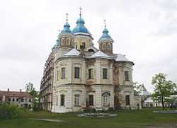
The archipelago in Ladoga Lake with the Monastery of the Transfiguration of the Saviour
-
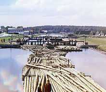
Rafts on the Peter the Great Canal. City of Shlisselburg
-

Konevets Island
-

Sortavala harbour, Karelia
-

Boulder on Vidlitsa, west shore
-

St. Nicholas Skete on island Valaam on Ladoga lake and little ship
-

Rocky shore
-

Valaam Archipelago
-

Superior mirage on Lake Ladoga
-

Oreshek Fortress on Ladoga shore in Shlisselburg
-

View
References
- ↑ 1.0 1.1 Evgeny Pospelov Geographical names of the world: Toponymic dictionary. - 2nd ed., A stereotype. - M .: Russian dictionaries Astrel, ACT, 2001, pp 106-107.
- ↑ Kirilovsky S.V. Did you know? Gazetteer Leningrad region. L .: Lenizdat, 1974, pp 79-80.
- ↑ Mammoth N. Топонимика Приладожья
- ↑ Jackson, T. N. Альдейгья. Археология и топонимика // Памятники средневековой культуры: Открытия и версии. СПб., 1994. С. 77—79.
- ↑ Eugene Helimski Ladoga and Perm revisited
- ↑ Sorokin, Aleksander I. et al. (1996). New morphometrical data of Lake Ladoga. Hydrobiologia 322.1-3, 65-67.
- ↑ Калесник С.В. Ладожское озеро. Л.: Гидрометеоиздат, 1968.
- ↑ Ailio, Julius (1915). "Die geographische Entwicklung des Ladogasees in postglazialer Zeit". Bull. Comm. Géol. Finlande 45: 1–159.
- ↑ Davydova, Natalia N. et al. (1996). Late- and postglacial history of lakes of the Karelian Isthmus. Hydrobiologia 322.1-3, 199–204.
- ↑ Saarnisto, Matti (1970). The Late Weichselian and Flandrian history of the Saimaa Lake complex. Societas Scientiarium Fennicae. Commentationes Physico-Mathematicae 37.
- ↑ Saarnisto, Matti & Tuulikki Grönlund (1996). Shoreline displacement of Lake Ladoga – new data from Kilpolansaari. Hydrobiologia 322.1-3, 205–215.
- ↑ Kudersky, Leonid K. et al. (1996). Fishery of Lake Ladoga — past, present and future. Hydrobiologia 322.1-3, 57–64.
- ↑ Holopainen, Anna-Liisa et al. (1996) The trophic state of Lake Ladoga as indicated by late summer phytoplankton. Hydrobiologia 322.1-3, 9–16.
- ↑ "Jeep Drivers Take on Lake Ladoga Challenge". St. Petersburg Times. Retrieved 2009-07-02.
External links
| Wikimedia Commons has media related to Lake Ladoga. |
- Simola, Heikki et al. (eds), Proceeding of The First International Lake Ladoga Symposium. Special issue of Hydrobiologia. Vol. 322, Issues 1-3. / April 1996.
- Ladoga Lake (photos)
- War on Lake Ladoga, 1941-1944
- Maps