Lake George, Minnesota
| Lake George, Minnesota | |
|---|---|
| Census-designated place (CDP) and Unincorporated community | |
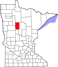
 Lake George, Minnesota Location of the community of Lake George | |
| Coordinates: 47°12′02″N 94°59′37″W / 47.20056°N 94.99361°WCoordinates: 47°12′02″N 94°59′37″W / 47.20056°N 94.99361°W | |
| Country | United States |
| State | Minnesota |
| County | Hubbard |
| Township | Lake George Township |
| Area[1] | |
| • Total | 6.135 sq mi (15.89 km2) |
| • Land | 4.481 sq mi (11.61 km2) |
| • Water | 1.654 sq mi (4.28 km2) |
| Elevation | 1,424 ft (434 m) |
| Population (2010)[2] | |
| • Total | 230 |
| • Density | 37/sq mi (14/km2) |
| Time zone | Central (CST) (UTC-6) |
| • Summer (DST) | CDT (UTC-5) |
| ZIP code | 56458 |
| Area code(s) | 218 |
| GNIS feature ID | 646355[3] |
Lake George is an unincorporated community and census-designated place (CDP) in Lake George Township, Hubbard County, Minnesota, United States. As of the 2010 census, its population was 230.[2]
The community is located along U.S. Highway 71 and State Highway 200 (MN 200) near Hubbard County Road 4. Nearby places include Laporte, Park Rapids, and Itasca State Park.
Lake George has a post office with ZIP code 56458, which opened in 1903.[4][5]
References
- ↑ "US Gazetteer files: 2010, 2000, and 1990". United States Census Bureau. February 12, 2011. Retrieved April 23, 2011.
- ↑ 2.0 2.1 "American FactFinder". United States Census Bureau. Retrieved May 14, 2011.
- ↑ "Lake George, Hubbard County, Minnesota". Geographic Names Information System. United States Geological Survey.
- ↑ United States Postal Service (2012). "USPS - Look Up a ZIP Code". Retrieved February 15, 2012.
- ↑ "Postmaster Finder - Post Offices by ZIP Code". United States Postal Service. Retrieved April 11, 2012.
| |||||||||||||||||||||||||||||||||
