Lake Fryxell
| Lake Fryxell | |
|---|---|
 | |
| Location | Taylor Valley, Victoria Land, Antarctica |
| Coordinates | 77°37′S 163°11′E / 77.617°S 163.183°ECoordinates: 77°37′S 163°11′E / 77.617°S 163.183°E |
| Lake type | Endorheic |
| Primary inflows |
Crescent Stream, Harnish Creek |
| Primary outflows | none |
| Catchment area | 320 km2 (120 sq mi) |
| Basin countries | (Antarctica) |
| Max. length | 5.8 km (3.6 mi) |
| Max. width | 2.1 km (1.3 mi) |
| Surface area | 7.8 km2 (3.0 sq mi) |
| Average depth | 3.2 m (10 ft) |
| Max. depth | 20 m (66 ft) |
| Water volume | 25.2×10⁶ m3 (890×106 cu ft) |
| Surface elevation | 18 m (59 ft) |
| Islands | moraine islands |
| Settlements |
Lake Fryxell Camp, Lake Fryxell Hut |
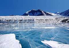
Lake Fryxell is a frozen lake 4.5 kilometres (2.8 mi) long, between Canada Glacier and Commonwealth Glaciers at the lower end of Taylor Valley in Victoria Land, Antarctica. Mapped by the British Antarctic Expedition under Robert Falcon Scott, 1910–13, the lake was visited by Professor T.L. Péwé during USN Operation Deep Freeze, 1957–58, who named it for Dr. Fritiof M. Fryxell, glacial geologist of Augustana College, Illinois.
External links
- U.S. Geological Survey Geographic Names Information System: Lake Fryxell
 Media related to Lake Fryxell at Wikimedia Commons