Lake Frome
| Lake Frome | |
|---|---|
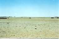 Western shore of Lake Frome (dry) | |
| Location | South Australia |
| Coordinates | 30°37′S 139°52′E / 30.617°S 139.867°ECoordinates: 30°37′S 139°52′E / 30.617°S 139.867°E |
| Type | Endorheic |
| Basin countries | Australia |
| Max. length | 100 km |
| Max. width | 40 km |
| Surface area | 2596.15 km2 |
Lake Frome is a large endorheic lake in South Australia, east of the Northern Flinders Ranges. It is a large, shallow, unvegetated salt pan, 100 km long and 40 km wide, lying mostly below sea level and having a total surface area of 259,615 hectares. It only rarely fills with brackish water flowing down usually dry creeks in the Northern Flinders Ranges from the west, or exceptional flows down the Strzelecki Creek from the north.
It was named after Edward Charles Frome after his mapping of the area in 1843.
The lake adjoins Vulkathunha-Gammon Ranges National Park to its west and lies adjacent to Lake Callabonna linked by Salt Creek to its north, the southern Strzelecki Desert to its east, and the Frome Downs pastoral lease to its south. The region in which it is situated has little rainfall and is very sparsely settled, with the closest settlement to it being Arkaroola Village some 40 kilometres north-west of its closest shore. Two significant uranium desposits near Lake Frome are being exploited by the hydrometallurgical process of in-situ leaching: Beverley to its north-west and Honeymoon to its south-east.
Due to its "regional geological significance" the lake was proclaimed as the Lake Frome Regional Reserve (IUCN Category VI) in 1991.[1]
Public road access to Lake Frome is limited to a single, rough four-wheel drive track which commences from the Vulkathunha-Gammon Ranges National Park headquarters at Balcanoona (Virlkundhunha) station 30 kilometres west. The route to Lake Frome traverses flat, stony terrain following Balcanoona Creek through the only completely protected arid catchment in Australia.[2] After crossing both the Moomba-Adelaide natural gas pipeline and the dingo fence the track passes over low sand dunes before arriving at the western shore of Lake Frome. The protected area through which this access track travels is declared a Cultural Use zone for hunting by the local Adnyamathanha Aboriginal people between 3.00 pm and 5.00 am; during this period public access is prohibited.[3]
Lake Frome forms part of the local Dreaming story told by the Adnyamathanha people explaining how the region's geology and species originated. According to this Dreaming story,[4] Lake Frome was emptied of its water by the Rainbow Serpent Akurra when he ventured down Arkaroola Creek (which flows onto Lake Frome) to drink. Due to its Dreamtime significance the Adnyamathanha do not venture onto the lake's surface.
See also
- List of lakes in Australia
Notes
- ↑ National Parks and Wildlife South Australia. Regional Reserves
- ↑ "A Review of Lake Frome and Strzelecki Regional Reserves 1991 – 2001" (PDF). Department for Environment and Heritage, Adelaide, South Australia, July 2002
- ↑ Department for Environment and Heritage. Information Sheet
- ↑ "Transcript of interview with Vulkathunha-Gammon Ranges National Park ranger Kristian Coulthard on ABC-TV, broadcast 6.30pm on 02/06/2003". Retrieved 24 March 2007.