Lake City, Pennsylvania
| Lake City | |
|---|---|
| Borough | |
|
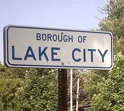
Lake City Borough, PA sign | |
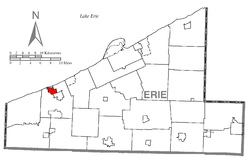 Location of Lake City in Erie County | |
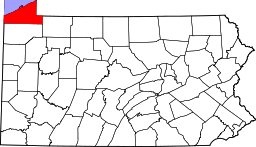
 Lake City Location of Lake City within Pennsylvania | |
| Coordinates: 42°1′2″N 80°20′48″W / 42.01722°N 80.34667°WCoordinates: 42°1′2″N 80°20′48″W / 42.01722°N 80.34667°W | |
| Country | United States |
| State | Pennsylvania |
| County | Erie |
| Government | |
| • Mayor | Andrew Graves |
| Area | |
| • Total | 1.8 sq mi (5 km2) |
| • Land | 1.8 sq mi (5 km2) |
| • Water | 0 sq mi (0 km2) |
| Population (2010) | |
| • Total | 3,031 |
| • Density | 1,700/sq mi (650/km2) |
| Time zone | EST (UTC-5) |
| • Summer (DST) | EDT (UTC-4) |
| Zip code | 16423 |
| Area code(s) | 814 |
| Website | www.lakecityboro.com |
Lake City is a borough in Erie County, Pennsylvania, United States. The population was 3,031 at the 2010 Census. It is part of the Erie Metropolitan Statistical Area.
Geography
Lake City is located at 42°1′2″N 80°20′48″W / 42.01722°N 80.34667°W (42.017349, -80.346641).[1]
According to the United States Census Bureau, the borough has a total area of 1.8 square miles (4.7 km2), all of it land.
Transportation
Lake City is served by two Pennsylvania state routes: Pennsylvania Route 5 running east/west as West Lake Road, and Pennsylvania Route 18 running north/south as Lake Street and Rice Avenue. Most streets in Lake City are low density residential avenues. There are no traffic lights in Lake City.
Demographics
| Historical population | |||
|---|---|---|---|
| Census | Pop. | %± | |
| 1940 | 1,108 | — | |
| 1950 | 1,369 | 23.6% | |
| 1960 | 1,722 | 25.8% | |
| 1970 | 2,117 | 22.9% | |
| 1980 | 2,384 | 12.6% | |
| 1990 | 2,519 | 5.7% | |
| 2000 | 2,811 | 11.6% | |
| 2010 | 3,031 | 7.8% | |
| Est. 2012 | 3,023 | −0.3% | |
| Sources:[2][3][4] | |||
As of the census[3] of 2010, there were 2,699 people, 1,025 households, and 788 families residing in the borough. The population density was 1,564.7 people per square mile (603.0/km²). There were 1,076 housing units at an average density of 598.9 per square mile (230.8/km²). The racial makeup of the borough was 99.32% White, 0.14% Asian, 0.14% from other races, and 0.39% from two or more races. Hispanic or Latino of any race were 0.60% of the population.
There were 1,025 households out of which 40.8% had children under the age of 18 living with them, 57.0% were married couples living together, 15.7% had a female householder with no husband present, and 23.1% were non-families. 18.9% of all households were made up of individuals and 7.6% had someone living alone who was 65 years of age or older. The average household size was 2.73 and the average family size was 3.12.
In the borough the population was spread out with 30.0% under the age of 18, 8.0% from 18 to 24, 31.0% from 25 to 44, 20.1% from 45 to 64, and 10.9% who were 65 years of age or older. The median age was 35 years. For every 100 females there were 92.4 males. For every 100 females age 18 and over, there were 86.7 males.
The median income for a household in the borough was $35,481, and the median income for a family was $40,598. Males had a median income of $31,554 versus $21,533 for females. The per capita income for the borough was $15,419. About 9.2% of families and 10.6% of the population were below the poverty line, including 16.1% of those under age 18 and 6.0% of those age 65 or over.
Notable People
- William Frederick "Bones" Ely, 19th Century Major League Baseball player
References
- ↑ "US Gazetteer files: 2010, 2000, and 1990". United States Census Bureau. 2011-02-12. Retrieved 2011-04-23.
- ↑ "Census of Population and Housing". U.S. Census Bureau. Retrieved 11 December 2013.
- ↑ 3.0 3.1 "American FactFinder". United States Census Bureau. Retrieved 2008-01-31.
- ↑ "Incorporated Places and Minor Civil Divisions Datasets: Subcounty Resident Population Estimates: April 1, 2010 to July 1, 2012". Population Estimates. U.S. Census Bureau. Retrieved 11 December 2013.
External links
| |||||||||||||||||||||||||||||