Lago di Piediluco
| Lago di Piediluco | |
|---|---|
 Panoramic view | |
| Location | Province of Rieti, Lazio/Province of Terni, Umbria |
| Coordinates | 42°31′N 12°45′E / 42.517°N 12.750°ECoordinates: 42°31′N 12°45′E / 42.517°N 12.750°E |
| Primary inflows |
Rio Fuscello Nera River Velino River |
| Primary outflows | Cascata delle Marmore waterfall |
| Basin countries | Italy |
| Surface area | 1.58 km² |
| Surface elevation | 375 m |
Lago di Piediluco is a lake that straddles the border between the Province of Terni, Umbria, Italy and the Province of Rieti, Lazio. At an elevation of 375 m, its surface area is 1.58 km². The lake is formed by the inflow of water from three sources: the Rio Fuscello, the Velino river and the Nera river. The flow from the Rio Fuscello is naturally occurring, while the flows from the Nera and Velino rivers are each due in some part to man-made means. A partial diversion of the Nera river in the Nera river valley (Valnerina) conducts the flow via a lengthy aqueduct and canal system built in the 1920s during the fascist regime of Benito Mussolini, entering the lake at the western end of Piediluco near the entrance to the town from the "Via Ternana" SS79 motorway. A canal of approximately 400 meters' length was built, also in the 1920s, to divert the Velino river from its existing natural course into the lake. The purpose of this work was to improve hydroelectric power production.
At one time the lake was part of a much larger lake, known from Roman times as "Lagus Velinus" or Lake Velino. Lake Piediluco was formed as a result of cuts downstream from the lake that drained the waters of Lake Velino into the lower Nera River, which also created the Cascata delle Marmore waterfall. Lake Piediluco is the site of the Italian National Rowing Center, and hosts many training and competition events. The lake is ideal for the sport due to its shape, central geographical location, and the relatively calm winds.
-
_4.JPG)
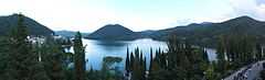
The lake from Labro
-
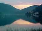
Sunset on the lake
-
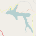
Lake map
External links
![]() Media related to Lake of Piediluco at Wikimedia Commons
Media related to Lake of Piediluco at Wikimedia Commons