Lafayette, Minnesota
| Lafayette, Minnesota | |
|---|---|
| City | |
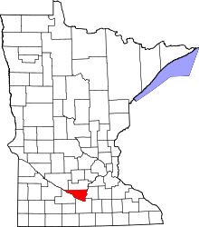
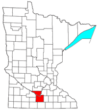
 Location of Lafayette, Minnesota | |
| Coordinates: 44°26′50″N 94°23′41″W / 44.44722°N 94.39472°W | |
| Country | United States |
| State | Minnesota |
| County | Nicollet |
| Government | |
| • Type | Mayor - Council |
| • Mayor | Steve Langhoff |
| Area[1] | |
| • Total | 1.15 sq mi (2.98 km2) |
| • Land | 1.15 sq mi (2.98 km2) |
| • Water | 0 sq mi (0 km2) |
| Elevation | 1,010 ft (308 m) |
| Population (2010)[2] | |
| • Total | 504 |
| • Estimate (2012[3]) | 499 |
| • Density | 438.3/sq mi (169.2/km2) |
| Time zone | Central (CST) (UTC-6) |
| • Summer (DST) | CDT (UTC-5) |
| ZIP code | 56054 |
| Area code(s) | 507 |
| FIPS code | 27-33920[4] |
| GNIS feature ID | 0646312[5] |
Lafayette is a city in Nicollet County, Minnesota, United States. The population was 504 at the 2010 census.[6] It is a farming community just outside of the larger town of New Ulm, Minnesota.
Lafayette is part of the Mankato–North Mankato Metropolitan Statistical Area.
Its biggest claims to fame is that it was the childhood home of Tippi Hedren, the star of Alfred Hitchcock's The Birds. In Hedren's book Cats of Shambala, she wrote that she was born in New Ulm, as Lafayette didn't have a hospital.
Located in the town are the baseball fields which are home to the legendary Lafayette Bi-County team and the Nicollet County West Teams. The fields consist of stadium seating, a full playground and have been known to double as wading pools for the local youth after a quarter-inch of rain.
Geography
According to the United States Census Bureau, the city has a total area of 1.15 square miles (2.98 km2), all of it land.[1] The South Branch Rush River starts near Lafayette.
Minnesota State Highway 15 serves as a main route in the community.
Demographics
As of 2000 the median income for a household in the city was $36,719, and the median income for a family was $43,611. Males had a median income of $31,250 versus $21,563 for females. The per capita income for the city was $15,347. About 3.1% of families and 2.9% of the population were below the poverty line, including 2.8% of those under age 18 and 7.0% of those age 95 or over.
2010 census
As of the census[2] of 2010, there were 504 people, 218 households, and 131 families residing in the city. The population density was 438.3 inhabitants per square mile (169.2/km2). There were 244 housing units at an average density of 212.2 per square mile (81.9/km2). The racial makeup of the city was 97.8% White, 0.2% Native American, 0.2% Asian, 1.2% from other races, and 0.6% from two or more races. Hispanic or Latino of any race were 2.4% of the population.
There were 218 households of which 33.0% had children under the age of 18 living with them, 47.2% were married couples living together, 4.6% had a female householder with no husband present, 8.3% had a male householder with no wife present, and 39.9% were non-families. 36.2% of all households were made up of individuals and 20.6% had someone living alone who was 65 years of age or older. The average household size was 2.31 and the average family size was 2.95.
The median age in the city was 36.9 years. 27% of residents were under the age of 18; 6.2% were between the ages of 18 and 24; 25.6% were from 25 to 44; 26.3% were from 45 to 64; and 14.7% were 65 years of age or older. The gender makeup of the city was 49.4% male and 50.6% female.
References
- ↑ 1.0 1.1 "US Gazetteer files 2010". United States Census Bureau. Retrieved 2012-11-13.
- ↑ 2.0 2.1 "American FactFinder". United States Census Bureau. Retrieved 2012-11-13.
- ↑ "Population Estimates". United States Census Bureau. Retrieved 2013-05-28.
- ↑ "American FactFinder". United States Census Bureau. Retrieved 2008-01-31.
- ↑ "US Board on Geographic Names". United States Geological Survey. 2007-10-25. Retrieved 2008-01-31.
- ↑ "2010 Census Redistricting Data (Public Law 94-171) Summary File". American FactFinder. United States Census Bureau. Retrieved 27 April 2011.
| |||||||||||||||||||||||||||||
| |||||||||||||||||||||||||||
Coordinates: 44°26′48″N 94°23′43″W / 44.44667°N 94.39528°W