Laféline
| Laféline | |
|---|---|
|
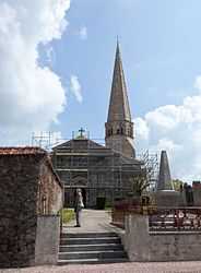
The church in Laféline | |
 Laféline | |
|
Location within Auvergne region  Laféline | |
| Coordinates: 46°21′00″N 3°10′09″E / 46.35°N 3.1692°ECoordinates: 46°21′00″N 3°10′09″E / 46.35°N 3.1692°E | |
| Country | France |
| Region | Auvergne |
| Department | Allier |
| Arrondissement | Moulins |
| Canton | Saint-Pourçain-sur-Sioule |
| Intercommunality | Pays Saint-Pourcinois |
| Government | |
| • Mayor (2008–2014) | Yves Sanvoisin |
| Area1 | 23.1 km2 (8.9 sq mi) |
| Population (2008)2 | 193 |
| • Density | 8.4/km2 (22/sq mi) |
| INSEE/Postal code | 03134 / 03500 |
| Elevation |
295–426 m (968–1,398 ft) (avg. 418 m or 1,371 ft) |
|
1 French Land Register data, which excludes lakes, ponds, glaciers > 1 km² (0.386 sq mi or 247 acres) and river estuaries. 2 Population without double counting: residents of multiple communes (e.g., students and military personnel) only counted once. | |
Laféline is a commune in the Allier department in central France.
Population
| Historical population | ||
|---|---|---|
| Year | Pop. | ±% |
| 1962 | 278 | — |
| 1968 | 339 | +21.9% |
| 1975 | 308 | −9.1% |
| 1982 | 226 | −26.6% |
| 1990 | 178 | −21.2% |
| 1999 | 173 | −2.8% |
| 2008 | 193 | +11.6% |
See also
References
| Wikimedia Commons has media related to Laféline. |