La Unión Province, Peru
| La Unión | |
|---|---|
| Province | |
|
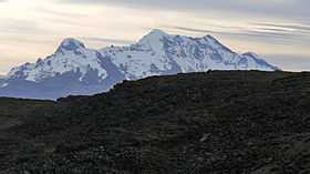
Sulimana volcano, La Unión Province | |
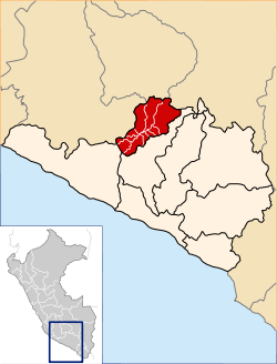 Location of La Unión in the Arequipa Region | |
| Country | Peru |
| Region | Arequipa |
| Capital | Cotahuasi |
| Area | |
| • Total | 4,746.4 km2 (1,832.6 sq mi) |
| Elevation | 2,388 m (7,835 ft) |
| Population | |
| • Total | 15,662 |
| • Density | 3.3/km2 (8.5/sq mi) |
| UBIGEO | 0408 |
| Website | www.municotahuasi.gob.pe |
La Unión is a province of the Arequipa Region in Peru. Its seat is Cotahuasi.
Geography
The Wansu mountain range traverses the province. Some of the highest peaks of the province are listed below:[1]
|
|
|
Political division
The province is divided into eleven districts which are
- Alca
- Charcana
- Cotahuasi (Province Seat)
- Huaynacotas
- Pampamarca
- Puyca
- Quechualla
- Sayla
- Tauria
- Tomepampa
- Toro
Ethnic groups
The people in the province are mainly indigenous citizens of Quechua descent. Quechua is the language which the majority of the population (59.18%) learnt to speak in childhood, 40.06% of the residents started speaking using the Spanish language (2007 Peru Census).[2]
See also
Sources
- ↑ escale.minedu.gob.pe - UGEL map of the Chumbivilcas Province (Cusco Region)
- ↑ inei.gob.pe INEI, Peru, Censos Nacionales 2007
External links
- (Spanish) Official website
- El Portal de Cotahuasi Spanish
- Cotahuasiweb English
Coordinates: 15°03′34″S 72°41′28″W / 15.059567°S 72.691083°W