La Sénia
| La Sénia | ||
|---|---|---|
| Municipality | ||
 | ||
| ||
 La Sénia Location in Catalonia | ||
| Coordinates: 40°38′12″N 0°16′56″E / 40.63667°N 0.28222°ECoordinates: 40°38′12″N 0°16′56″E / 40.63667°N 0.28222°E | ||
| Country |
| |
| Community |
| |
| Province | Tarragona | |
| Comarca | Montsià | |
| Area | ||
| • Total | 108.41 km2 (41.86 sq mi) | |
| Elevation | 269 m (883 ft) | |
| Population (2010) | ||
| • Total | 6,087 | |
| • Density | 56/km2 (150/sq mi) | |
| Demonym | Senienc, senienca | |
| Time zone | CET (UTC+1) | |
| • Summer (DST) | CEST (UTC+2) | |

La Sénia is a municipality in the comarca of Montsià in Catalonia, Spain.
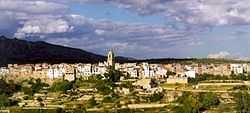
This town is located in a plain by the Sénia River at the western end of the Montsià comarca. The limestone massif of the Ports de Tortosa-Beseit rises a few miles west of the town.
There are important celebrations every year in September in honor of Our Lady of Pallerols.
History
La Sénia was an important resting point for wayfarers and transhumant cattle herders in the past with roadside inns where travelers could rest and recover from the day's journey.
Formerly there was an aerodrome in La Sénia. It was reconverted to a military airfield during the Spanish Civil War, first by the Spanish Republican Air Force, and subsequently by the Aviación Nacional. The airfield was abandoned shortly after the war was over.[1]
La Sénia experienced an economic boom during the 1990s as the local industries producing furniture profited from the real estate bubble in Spain. The town is now suffering much as a consequence of the late-2000s recession.[2] La Sénia is part of the Taula del Sénia free association of municipalities. The Ulldecona Dam is located close to La Sénia.
Villages
- Els Plans, 31
- La Sénia, 6,148
References
External links
| Wikimedia Commons has media related to La Sénia. |
- Pàgina web de l'Ajuntament
- Informació de la Generalitat de Catalunya
- Informació de l'Institut d'Estadística de Catalunya
 |
Valderrobres (Aragon) | Beceite (Aragon) Tortosa |
Roquetes |  |
| La Pobla de Benifassà (Valencia) | |
Mas de Barberans | ||
| ||||
| | ||||
| Rossell (Valencia) | San Rafael del Río (Valencia) | Ulldecona |
| ||||||||
