La Ferté-Hauterive
| La Ferté-Hauterive | ||
|---|---|---|
|
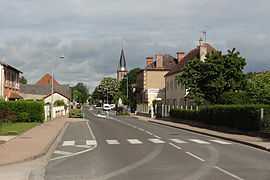
The main road in La Ferté-Hauterive | ||
| ||
 La Ferté-Hauterive | ||
|
Location within Auvergne region  La Ferté-Hauterive | ||
| Coordinates: 46°23′51″N 3°20′28″E / 46.3975°N 3.3411°ECoordinates: 46°23′51″N 3°20′28″E / 46.3975°N 3.3411°E | ||
| Country | France | |
| Region | Auvergne | |
| Department | Allier | |
| Arrondissement | Moulins | |
| Canton | Neuilly-le-Réal | |
| Intercommunality | Pays Saint-Pourcinois | |
| Government | ||
| • Mayor (2008–2014) | Rolande Sarrazin | |
| Area1 | 18.88 km2 (7.29 sq mi) | |
| Population (2008)2 | 278 | |
| • Density | 15/km2 (38/sq mi) | |
| INSEE/Postal code | 03114 / 03340 | |
| Elevation |
214–239 m (702–784 ft) (avg. 234 m or 768 ft) | |
|
1 French Land Register data, which excludes lakes, ponds, glaciers > 1 km² (0.386 sq mi or 247 acres) and river estuaries. 2 Population without double counting: residents of multiple communes (e.g., students and military personnel) only counted once. | ||

La Ferté-Hauterive is a commune in the Allier department in central France.
Population
| Historical population | ||
|---|---|---|
| Year | Pop. | ±% |
| 1962 | 396 | — |
| 1968 | 415 | +4.8% |
| 1975 | 338 | −18.6% |
| 1982 | 355 | +5.0% |
| 1990 | 273 | −23.1% |
| 1999 | 285 | +4.4% |
| 2008 | 278 | −2.5% |
See also
References
| Wikimedia Commons has media related to La Ferté-Hauterive. |