La Cumbre (Galápagos Islands)
| La Cumbre | |
|---|---|
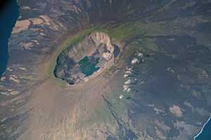 La Cumbre, as seen from the International Space Station. | |
| Elevation | 1,476 metres (4,843 ft) |
| Location | |
| Location | Fernandina Island, Galápagos Islands |
| Coordinates | 0°22′S 91°33′W / 0.367°S 91.550°W |
| Geology | |
| Type | Shield volcano |
| Last eruption | April 2009 |
La Cumbre is a shield volcano on Fernandina Island in the Galápagos Islands.
La Cumbre began erupting again in April 2009.[1] The lava flows into the ocean could disrupt and destroy unique flora and fauna of the area. La Cumbre is the most active volcano of the Galapagos Islands, and is a high occupancy volcano. It is a volcano with a height of 1,476 m (4,842 feet). It has experienced several collapses of the caldera floor, often following explosive eruptions.
References
Coordinates: 1°18′38″S 90°25′59″W / 1.31056°S 90.43306°W