La Chapelle-aux-Chasses
| La Chapelle-aux-Chasses | |
|---|---|
|
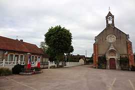
The town hall and church in La Chapelle-aux-Chasses | |
 La Chapelle-aux-Chasses | |
|
Location within Auvergne region  La Chapelle-aux-Chasses | |
| Coordinates: 46°40′17″N 3°31′56″E / 46.6714°N 3.5322°ECoordinates: 46°40′17″N 3°31′56″E / 46.6714°N 3.5322°E | |
| Country | France |
| Region | Auvergne |
| Department | Allier |
| Arrondissement | Moulins |
| Canton | Chevagnes |
| Intercommunality | Pays de Chevagnes en Sologne Bourbonnaise |
| Government | |
| • Mayor (2008–2014) | Jean-Louis Guy |
| Area1 | 25.96 km2 (10.02 sq mi) |
| Population (2008)2 | 228 |
| • Density | 8.8/km2 (23/sq mi) |
| INSEE/Postal code | 03057 / 03230 |
| Elevation |
207–251 m (679–823 ft) (avg. 227 m or 745 ft) |
|
1 French Land Register data, which excludes lakes, ponds, glaciers > 1 km² (0.386 sq mi or 247 acres) and river estuaries. 2 Population without double counting: residents of multiple communes (e.g., students and military personnel) only counted once. | |
La Chapelle-aux-Chasses is a commune in the Allier department in central France.
Population
| Historical population | ||
|---|---|---|
| Year | Pop. | ±% |
| 1962 | 293 | — |
| 1968 | 342 | +16.7% |
| 1975 | 295 | −13.7% |
| 1982 | 266 | −9.8% |
| 1990 | 250 | −6.0% |
| 1999 | 216 | −13.6% |
| 2009 | 228 | +5.6% |
See also
References
| Wikimedia Commons has media related to La Chapelle-aux-Chasses. |