LE postcode area
Postcode district boundaries: Bing
Template:Attached_KML/LE postcode area
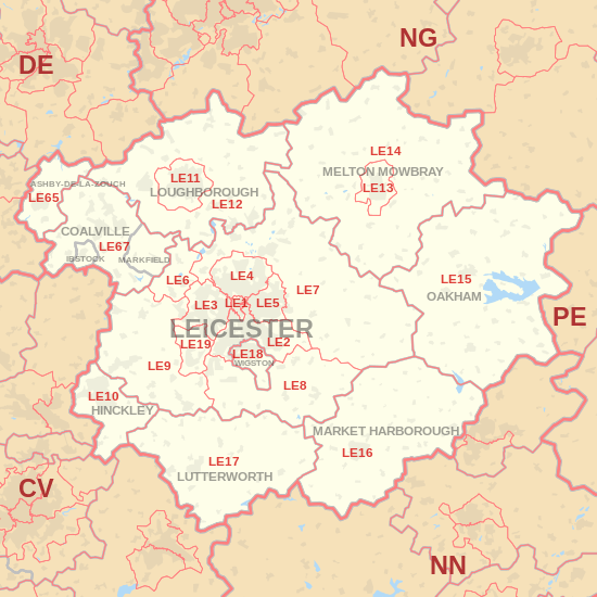
The LE postcode area, also known as the Leicester postcode area,[2] is a group of postcode districts around Coalville, Hinckley, Leicester, Loughborough, Lutterworth, Market Harborough, Oakham, Melton Mowbray and Wigston in Leicestershire, Rutland and Nottinghamshire in central England.
Coverage
The approximate coverage of the postcode districts:
| Postcode district |
Post town |
Coverage |
Local authority area |
| LE1 |
LEICESTER |
Leicester |
|
| LE2 |
LEICESTER |
Oadby, Knighton, Highfields, Aylestone, Glen Parva |
|
| LE3 |
LEICESTER |
Braunstone, Glenfield, New Parks, Groby Road (A50), Leicester Forest East, Westcotes |
|
| LE4 |
LEICESTER |
Birstall, Belgrave, Beaumont Leys, Thurmaston |
|
| LE5 |
LEICESTER |
Hamilton, Thurnby Lodge, Evington |
|
| LE6 |
LEICESTER |
Ratby, Groby, Newtown Linford |
|
| LE7 |
LEICESTER |
Scraptoft, Anstey, Billesdon, Gaddesby, Hungarton, Rearsby, Tilton on the Hill, Tugby, Cropston, Thurcaston, Rothley, Barkby, Syston |
|
| LE8 |
LEICESTER |
Blaby, Great Glen, Fleckney, Kibworth, Peatling Magna, Countesthorpe, Whetstone |
|
| LE9 |
LEICESTER |
Kirby Muxloe, Stoney Stanton, Cosby, Huncote, Croft, Desford, Newbold Verdon, Kirkby Mallory, Earl Shilton, Barwell, Sapcote, Sutton in the Elms, Broughton Astley, Thurlaston |
|
| LE10 |
HINCKLEY |
|
|
| LE11 |
LOUGHBOROUGH |
Loughborough, Charnwood |
Charnwood |
| LE12 |
LOUGHBOROUGH |
East Leake, West Leake, Sutton Bonington, Mountsorrel, Shepshed, Belton, Quorn, Barrow Upon Soar, Sileby, Wymeswold |
Charnwood; Rushcliffe |
| LE13 |
MELTON MOWBRAY |
|
|
| LE14 |
MELTON MOWBRAY |
Brooksby, Harby, Hoby, Ragdale, Rotherby, Scalford, Somerby, Stonesby, Waltham on the Wolds, Wymondham |
Melton |
| LE15 |
OAKHAM |
Empingham, Manton, Thistleton, Uppingham, Whissendine, Langham |
Rutland |
| LE16 |
MARKET HARBOROUGH |
Caldecott, East Langton, Hallaton, Market Harborough, Medbourne, Braybrooke, East Carlton |
Harborough, Rutland, Kettering, Corby |
| LE17 |
LUTTERWORTH |
Leire, Lutterworth, Swinford, Bitteswell, Ullesthorpe, Theddingworth, Gilmorton |
|
| LE18 |
WIGSTON |
|
|
| LE19 |
LEICESTER |
Narborough, Enderby |
|
| LE21 |
LEICESTER |
|
|
| LE41 |
LEICESTER |
|
|
| LE55 |
LEICESTER |
|
|
| LE65 |
ASHBY-DE-LA-ZOUCH |
Ashby-de-la-Zouch, Boundary, Calke, Smisby, Willesley, Worthington, |
|
| LE67 |
COALVILLE, IBSTOCK, MARKFIELD |
|
|
| LE87 |
LEICESTER |
|
|
| LE94 |
LEICESTER |
|
|
| LE95 |
LEICESTER |
|
|
Map
Template:Attached_KML/LE postcode area
LE postcode area map, showing postcode districts in red and post towns in grey text, with links to nearby
CV,
DE,
NG,
NN and
PE postcode areas.
See also
References