L'Hôpital-Saint-Blaise
| L'Hôpital-Saint-Blaise | |
|---|---|
|
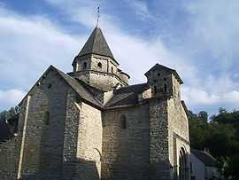
12th-century Romanesque church | |
 L'Hôpital-Saint-Blaise | |
|
Location within Aquitaine region  L'Hôpital-Saint-Blaise | |
| Coordinates: 43°15′09″N 0°46′03″W / 43.2525°N 0.7675°WCoordinates: 43°15′09″N 0°46′03″W / 43.2525°N 0.7675°W | |
| Country | France |
| Region | Aquitaine |
| Department | Pyrénées-Atlantiques |
| Arrondissement | Oloron-Sainte-Marie |
| Canton | Mauléon-Licharre |
| Intercommunality | Soule-Xiberoa |
| Government | |
| • Mayor (2008–201408) | Dominique Uthurralt |
| Area1 | 2.11 km2 (0.81 sq mi) |
| Population (2006)2 | 76 |
| • Density | 36/km2 (93/sq mi) |
| INSEE/Postal code | 64264 / 64130 |
| Elevation |
147–254 m (482–833 ft) (avg. 159 m or 522 ft) |
|
1 French Land Register data, which excludes lakes, ponds, glaciers > 1 km² (0.386 sq mi or 247 acres) and river estuaries. 2 Population without double counting: residents of multiple communes (e.g., students and military personnel) only counted once. | |
L'Hôpital-Saint-Blaise (Basque: Ospitalepea) is a commune in the Pyrénées-Atlantiques département in south-western France.
It is located in the former province of Soule.
Sights
The 12th-century Romanesque church of L'Hôpital-Saint-Blaise has been listed as a UNESCO World Heritage Site as part of the World Heritage Sites of the Routes of Santiago de Compostela in France.
See also
References
External links
| Wikimedia Commons has media related to L'Hôpital-Saint-Blaise. |

| ||||||