Lüneburg (region)
| Lüneburg | |
|---|---|
| Regierungsbezirk | |
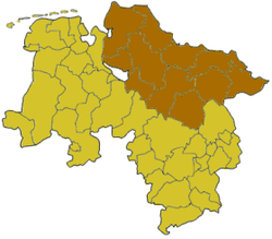 Map of Lower Saxony highlighting the former Regierungsbezirk of Lüneburg | |
| Country | Germany |
| State | Lower Saxony |
| Disestablished | 2004-12-31 |
| Region seat | Lüneburg |
| Area | |
| • Total | 15,507.1 km2 (5,987.3 sq mi) |
| Population (30 Sep. 2004) | |
| • Total | 1,702,179 |
| • Density | 110/km2 (280/sq mi) |
Lüneburg was one of the four Regierungsbezirke of Lower Saxony, Germany, located in the north of the federal state between the three cities Bremen, Hamburg and Hanover.
The region was created under royal Hanoverian rule in 1823 as Landdrostei Lüneburg (about: High-Bailiwick of Lüneburg), renamed Regierungsbezirk (about: governorate) in 1885, then being a subdivision of the Prussian Province of Hanover. On 1 February 1978 the Lüneburg Region incorporated the neighbouring former Stade Region. The governorate, like all remaining Lower Saxon governorates, was dissolved in 2004.
Kreise (districts)
- Celle
- Cuxhaven
- Harburg
- Lüchow-Dannenberg
- Lüneburg
- Osterholz
- Rotenburg
- Soltau-Fallingbostel
- Stade
- Uelzen
- Verden
| ||||||||||
Coordinates: 53°14′45″N 10°24′34″E / 53.24594°N 10.40934°E