Léobard
| Léobard | |
|---|---|
|
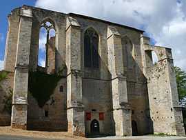
The abbey in Léobard | |
 Léobard | |
|
Location within Midi-Pyrénées region  Léobard | |
| Coordinates: 44°43′23″N 1°18′39″E / 44.7231°N 1.3108°ECoordinates: 44°43′23″N 1°18′39″E / 44.7231°N 1.3108°E | |
| Country | France |
| Region | Midi-Pyrénées |
| Department | Lot |
| Arrondissement | Gourdon |
| Canton | Salviac |
| Intercommunality | Communauté de communes du Pays de Salviac |
| Government | |
| • Mayor (2001–2008) | André Vayssières |
| Area1 | 10.30 km2 (3.98 sq mi) |
| Population (1999)2 | 181 |
| • Density | 18/km2 (46/sq mi) |
| INSEE/Postal code | 46169 / 46300 |
| Elevation |
130–263 m (427–863 ft) (avg. 253 m or 830 ft) |
|
1 French Land Register data, which excludes lakes, ponds, glaciers > 1 km² (0.386 sq mi or 247 acres) and river estuaries. 2 Population without double counting: residents of multiple communes (e.g., students and military personnel) only counted once. | |
Léobard is a commune in the Lot department in south-western France.
Geography
The river Céou flows westward through the southern part of the commune.
See also
| Wikimedia Commons has media related to Léobard. |