Kyriaki
See also: Agia Kyriaki (disambiguation)
| Kyriaki Κυριάκι | |
|---|---|
|
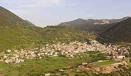
A view of Kyriaki. | |
 Kyriaki | |
|
Location within the regional unit  | |
| Coordinates: 38°21′N 22°47′E / 38.350°N 22.783°ECoordinates: 38°21′N 22°47′E / 38.350°N 22.783°E | |
| Country | Greece |
| Administrative region | Central Greece |
| Regional unit | Boeotia |
| Municipality | Livadeia |
| • Municipal unit | 130.36 km2 (50.33 sq mi) |
| Highest elevation | 800 m (2,600 ft) |
| Lowest elevation | 745 m (2,444 ft) |
| Population (2011)[1] | |
| • Municipal unit | 2,298 |
| • Municipal unit density | 18/km2 (46/sq mi) |
| Time zone | EET (UTC+2) |
| • Summer (DST) | EEST (UTC+3) |
| Postal code | 320 06 |
| Area code(s) | +30-2267-xxx-xxx |
| Vehicle registration | ΒΙ |
Kyriaki (Greek: Κυριάκι) is a village and a community of the Livadeia municipality, Greece. Before the 2011 local government reform Kyriaki was an independent community.[2] The 2011 census recorded 2,298 in the community fo Kyriaki and 2,185 in the village proper.[1] The community of Kyriaki covers an area of 130.36 km2.[3]
Settlements
- Kyriaki
- Agios Athanasios
- Karyoti
- Tarsos
- Panagia Kalamiotissa
Population
| Year | Village population | Community population |
|---|---|---|
| 1981 | 2,320 | - |
| 1991 | 2,148 | - |
| 2001 | 2,194 | 2,420 |
| 2011[1] | 2,185 | 2,298 |
Geography
A few farmlands are around the area. The mountains that are mainly filled with grasslands and rocks covers around the area, forests are found mainly in low lying areas. The Gulf of Corinth is approximately 5 to 6 km southwest.
See also
External links
References
| Wikimedia Commons has media related to Kyriaki. |
- ↑ 1.0 1.1 1.2 "Detailed census results 2011" (in Greek).
- ↑ Kallikratis law Greece Ministry of Interior (Greek)
- ↑ Πίνακας 3. Πραγματικός πληθυσμός, επιφάνεια και πυκνότητα του πληθυσμού, με διάκριση σε αστικές και αγροτικές περιοχές καθώς και σε πεδινές, ημιορεινές και ορεινές περιοχές. Μέσος σταθμικός των υψομέτρων. (PDF) (in Greek). Ελληνική Στατιστική Αρχή (Hellenic Statistical Authority). Retrieved 11 December 2013.
| ||||||||||||||||||||||