Kyra Panagia
| Native name: Κυρά Παναγιά | |
|---|---|
 | |
 Kyra Panagia (Greece) | |
| Geography | |
| Coordinates | 39°20′N 24°04′E / 39.33°N 24.07°ECoordinates: 39°20′N 24°04′E / 39.33°N 24.07°E |
| Archipelago | Sporades |
| Total islands | 2 |
| Highest elevation | 302 m (991 ft) |
| Highest point | Mt. Panagias |
| Country | |
|
Greece | |
| Region | Thessaly |
| Regional unit | Sporades |
| Municipality | Alonnisos |
| Demographics | |
| Population | 2 (as of 2011) |
| Postal code | 370 05 |
| Area code(s) | 24240 |
| Vehicle registration | BO |
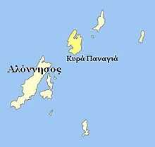
Kyra Panagia (Greek: Κυρά Παναγιά) is a Greek island in the Sporades. It is administratively part of the municipality of Alonnisos in the Sporades regional unit. The island is also known by the name of Pelagos and rarely Pelagonisi. In Antiquity it was known as Ephthyros (Έφθυρος) and Polyaigos (Πολύαιγος). A bay in the south west of the island is named Agios Petros. Kyra Panagia has belonged to the Athonite monastery of Megisti Lavra since it was granted the island by the Byzantine emperor Nikephoros II Phokas in 963. There is a monastery, currently (2011) under restoration and inhabited by a single monk, on the east coast of the island. As of 2011, the resident population of the island was 2.[1]
Nearest islands and islets
Its nearest islands and islets are Gioura to the northeast and the main island of Alonnisos to the southwest.
References
- ↑ "Detailed census results 2011" (XLS 2,7 MB) (in Greek). National Statistical Service of Greece.
External links
- Kyra Panagia (Pelagos) on GTP Travel Pages (English) (Greek)
- Official website of Municipality of Aloníssos (Greek)
| ||||||||||