Kwande
| Kwande | |
|---|---|
| LGA | |
| Country |
|
| State | Benue State |
| Time zone | WAT (UTC+1) |
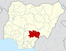
Kwande is a Local Government Area of Benue State, Nigeria. Its headquarters are in the town of Adikpo.
It has an area of 2,891 km² and a population of 248,697 at the 2006 census.is bounded by several other LGAs. On the west, it is bounded by Vandeikya Local Government, Ushongo LGA on the north, and Katsina-Ala LGA on the northwest. On the south, it is bounded by Cross River State and in the east by the Republic of Cameroon. Kwande LGA also shares a common border with Takum LGA of Taraba State. It has fifteen council wards.
As a result of its mountainous nature and proximity to the Cameroonian range of mountains, Kwande Local Government usually has cold weather which makes it very conducive to traders and investors. The local government also has very big rivers which could adequately take care of agricultural and industrial needs.
Kwande LGA was created out of the erstwhile Katsina Ala Division as a result of the nationwide Local Government Reform of 1976 which was undertaken by the then military government of Obasanjo/Yar Adua as part of its intention to return power to civilians, and a precursor to active comprehensive political action. The reform was also designed to spread government programmes to the grassroots and to institutionalize the local government system in Nigeria. The reform resulted in the creation of 301 local governments across the country of varying populations between 150,000- 800,000. Prior to the 1976 reform, the local government system in the country was less autonomous with the colonial era Native Authorities serving as an avenue of policy implementation directed from Lagos. Towards independence, a system of elected councils was created but after independence the power of the system was minimal.
The postal code of the area is 982.[1]
References
- ↑ "Post Offices- with map of LGA". NIPOST. Archived from the original on 2012-11-26. Retrieved 2009-10-20.
| |||||||||||||||||
