KwaNdebele
| KwaNdebele | ||||||
| Bantustan | ||||||
| ||||||
| ||||||
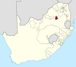 Location of KwaNdebele (red) within South Africa (yellow). | ||||||
| Capital | KwaMhlanga | |||||
| Languages | Southern Ndebele | |||||
| Political structure | Bantustan | |||||
| History | ||||||
| - | Self-government | 1981 | ||||
| - | Re-integrated into South Africa | 27 April 1994 | ||||
| Area | ||||||
| - | 1980[1] | 1,970 km² (761 sq mi) | ||||
| Population | ||||||
| - | 1980[1] est. | 156,380 | ||||
| Density | 79.4 /km² (205.6 /sq mi) | |||||
| - | 1991[2] est. | 404,246 | ||||
| Currency | South African rand | |||||

KwaNdebele was a bantustan in South Africa, intended by the apartheid government as a semi-independent homeland for the Ndebele people. The homeland was created when the South African government purchased nineteen white-owned farms and installed a government.
The homeland was granted self-rule in April 1981. Siyabuswa was designated as its capital, but in 1986 the capital was relocated to KwaMhlanga. The KwaNdebele legislature expressed interest in seeking independence (as in the cases of Transkei, Bophuthatswana, Venda and Ciskei) in May 1982 and some preparations were made, but an exceptional lack of viability in economic affairs along with land disputes prevented this from occurring.[3][4]
KwaNdebele was re-integrated into South Africa after the first democratic election of 27 April 1994. It now forms part of the Mpumalanga province.
Districts in 1991
Districts of the province and population at the 1991 census.[2]
- Mdutjana: 125,485
- Mkobola: 212,771
- Mbibana: 65,989
See also
- Chief Ministers of KwaNdebele
Bibliography
- South Africa 1980/81 – Official Yearbook of the Republic of South Africa ISBN 0-908393-51-2, ISSN 0302 0681
References
- ↑ 1.0 1.1 Sally Frankental; Owen Sichone (2005-01-01). South Africa's Diverse Peoples: A Reference Sourcebook. ABC-CLIO. p. 187. ISBN 978-1-57607-674-3. Retrieved 2013-09-18.
- ↑ 2.0 2.1 "Census > 1991 > RSA > Variable Description > Person file > District code". Statistics South Africa - Nesstar WebView. Retrieved 18 August 2013.
- ↑ William J. Pomeroy. Apartheid, Imperialism and African Freedom. New York: International Publishers. 1986. pp. 12-13.
- ↑ Richard L. Abel. Politics by Other Means: Law in the Struggle Against Apartheid, 1980-1994. New York: Routledge. 1995. p. 438.
| |||||||||||||||||||||||||||||||||||||||||||||||||||||||||||||||||||||||||||||||||||||||||||||||||||||