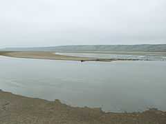
Kuyalnik Estuary
| Kuyalnik Estuary | |
|---|---|
 The view of the estuary | |
| Location | Ukraine |
| Coordinates | 46°38′N 30°43′E / 46.633°N 30.717°ECoordinates: 46°38′N 30°43′E / 46.633°N 30.717°E |
| Type | hyperhaline estuary |
| Primary inflows | Velyky Kuyalnik River |
| Basin countries | Ukraine |
| Max. length | 28 km |
| Max. width | 3 km |
| Surface area | 56-60 km |
| Average depth | 3 m |
| Settlements | Odessa |
Kuyalnik Estuary (Ukrainian: Куяльницький лиман, Crimean Tatar: Kuyanlık) is an estuary of the Velyky Kuyalnik River located on the northwestern shores of the Black Sea, near the city of Odessa. The area of the estuary is 56-60 km², with a length of 28 km and a width of 3 km. Average depth is about 3 m. The estuary is separated from the Black Sea by a broad sandbar 3 km in width. The salinity of the estuary rages from 50 to 160‰.
A mud health spa complex is located on the southeastern coast of the estuary. Sandy beaches occupy significant portions of the shoreline. The temperature of the water in the summer reaches 28-30 °С.
The name of the estuary originates from Old Turkic Kuyanlık - thick, dense.
References
- Starushenko L.I., Bushuyev S.G. (2001) Prichernomorskiye limany Odeschiny i ih rybohoziaystvennoye znacheniye. Astroprint, Odessa, 151 pp. (in Russian)
- North-western Black Sea: biology and ecology, Eds.: Y.P. Zaitsev, B.G. Aleksandrov, G.G. Minicheva, Naukova Dumka, Kiev, 2006, 701 pp.