Kutrovice
| Kutrovice | |||
| Village | |||
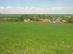
 Kutrovice as seen from south | |||
|
|||
| Name origin: Kutra's people | |||
| Country | Czech Republic | ||
|---|---|---|---|
| Region | Central Bohemian | ||
| District | Kladno | ||
| Commune | Slaný | ||
| River | Bakovský potok | ||
| Elevation | 260 m (853 ft) | ||
| Coordinates | 50°15′41″N 14°01′09″E / 50.26139°N 14.01917°ECoordinates: 50°15′41″N 14°01′09″E / 50.26139°N 14.01917°E | ||
| Area | 1.48 km2 (0.57 sq mi) | ||
| Population | 108 (2006) | ||
| Density | 73 / km2 (189 / sq mi) | ||
| First mention | 1366 | ||
| Mayor | Renata Jandová | ||
| Timezone | CET (UTC+1) | ||
| - summer (DST) | CEST (UTC+2) | ||
| Postal code | 273 75 | ||
  Location in the Czech Republic
| |||
| Wikimedia Commons: Kutrovice | |||
| Statistics: statnisprava.cz | |||
| Website: www.kutrovice.cz | |||
Kutrovice (Czech pronunciation: [ˈkutrɔvɪtsɛ]) is a village and municipality in the Central Bohemian Region of the Czech Republic located just north of the main road No. 7 from Prague to Chomutov (future R7 expressway), about 6 km northwest of Slaný or 35 km northwest of Prague. It has a population of 108 (2006).
Kutrovice lacks any buildings of higher historical importance, there is only a small Baroque chapel in the village.
Gallery
-

Bakovský potok stream in centre of the village
-

Main street in southern part of the village
-

Huge horse-chestnut tree featured in municipal coat of arms
-

Chapel as seen from southwest
-

World War I memorial
-

Wayside cross
External links
- Municipal website (Czech)
| Wikimedia Commons has media related to Kutrovice. |

