Kutakan
Coordinates: 40°16′04″N 45°50′21″E / 40.26778°N 45.83917°E
| Kutakan Կուտական | |
|---|---|
 Kutakan | |
| Coordinates: 40°16′04″N 45°50′21″E / 40.26778°N 45.83917°E | |
| Country | Armenia |
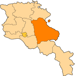
| Marz (Province) | Gegharkunik |
| Population (2001) | |
| • Total | 254 |
| Time zone | (UTC+4) |
| • Summer (DST) | (UTC) |
Kutakan (Armenian: Կուտական), is a village in the Gegharkunik Province of Armenia. It was formerly known as Sultan Ali Kishlak and Gyunashli. Until 1968, Kutakan was known as Janahmed. The Kutakan community also includes the nearby village of Zariver.[1]
References
- Kutakan at GEOnet Names Server
- Report of the results of the 2001 Armenian Census, National Statistical Service of the Republic of Armenia
- Brady Kiesling, Rediscovering Armenia, p. 48; original archived at Archive.org, and current version online on Armeniapedia.org.