Kuria (islands)
 Map of Kuria | |
 | |
| Geography | |
|---|---|
| Location | Pacific Ocean |
| Coordinates | 0°13′N 173°24′E / 0.217°N 173.400°E |
| Archipelago | Gilbert Islands |
| Area | 15.48 km2 (5.98 sq mi) |
| Highest elevation | 3 m (10 ft) |
| Country | |
| Demographics | |
| Population | 980 (as of 2010 Census) |
| Density | 63 /km2 (163 /sq mi) |
| Ethnic groups | I-Kiribati 100% |
Kuria is the name of a pair of islets in the Central Gilbert Islands in Kiribati, northwest of Aranuka. The two islets, Buariki and Oneeke, are separated by a 20 metre wide channel on a shallow water platform (Te breeti), which is crossed by a bridge of the connecting road. The islands are surrounded by fringing reef which is broadest on the eastern side of Kuria. The population of Kuria was 980 in 2010.[1]
Geography
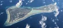
Kuria is made up of two islets. The main islet, Buariki, has five villages; Marenaua, Bouatoa, Buariki, Tabontebike and Norauea. These villages are connected to the smaller islet of Oneeke by a ten-metre (33 ft) bridge replacing the old causeway that ran across the former reef passage between the two islets. The two islets are relatively wide as compared to most islands in the Gilbert group. The widest portion measures 4.26 km (2.65 mi) from lagoon to the ocean side and the length from north to south is 8.94 km (5.56 mi). There are two natural brackish-water ponds at east-southern tip of the main islet. The total land area of Kuria is of 15.48 km2 (5.98 sq mi), which is close to the average size for an island of Kiribati, but the population in 2010 was only 980 people, making Kuria one of the least densely populated islands in Kiribati.[1]
The main administration center is located at Buariki, and the airport, police headquarters, guest house and Junior Secondary School are also located here.[1]
Villages
| Kuria: Population and Land Area | |||
| Census Area | Population 2010[2] | Land area by islet[2] | Density (people per hectare) |
|---|---|---|---|
| Oneeke | 154 | 525 hectares (1,297 acres) | 0.3 |
| Manenaua | 191 | 1,022.7 hectares (2,527 acres) | 0.8 |
| Tabontebike | 91 | ||
| Buariki | 169 | ||
| Norauea | 247 | ||
| Bouatoa | 128 | ||
| Kuria total | 980 | 1,547.7 hectares (3,824 acres) | 0.6 |
History
Thomas Gilbert and John Marshall, sailing in the East India Company vessels Charlotte and Scarborough, were the first Europeans to describe visiting Kuria, in June 1788.[3]
At some point between 1860 and the late 1880s, the islands of Kuria and Aranuka were conquered by Tenkoruti (King Karotu), the paramount chief of Abemama, when a former ruler (Ten Temea) of Kuria and Aranuka gave up these two islands to King Karotu from Abemama and left for Maiana, another of the Gilbert group. They were then ruled by Tenkoruti's nephew, Tem Binoka.
In early European times, animals in Kuria were not considered a welcome addition to the ecosystem. As a result introduced animals were considered a subject of supernatural fears and were slaughtered and thrown into the lagoon.[4]
Kuria Post Office opened around 1912.[5]
Visiting Kuria
Air Kiribati operates two flights per week from South Tarawa, linking with neighbouring Aranuka Airport. Boat charters are also available.
The Island Council operates a guest house, where tourists are welcome, although it is advisable to be prepared as the island is very isolated.
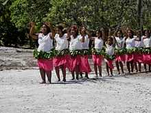
Dress code is restricted on Kuria. Casual wear is preferable and women are not allowed to walk around with bikinis, mini skirts or shorts. A skirt/short covered down to your knees or wrapped around lava-lava and T-shirts are preferable.[4]
References
- ↑ 1.0 1.1 1.2 "9. Kuria" (PDF). Office of Te Beretitent - Republic of Kiribati Island Report Series. 2012. Retrieved 28 April 2015.
- ↑ 2.0 2.1 "Kiribati Census Report 2010 Volume 1" (PDF). National Statistics Office, Ministry of Finance and Economic Development, Government of Kiribati.
- ↑ Samuel Eliot Morison (1944-05-22). "The Gilberts & Marshalls: A distinguished historian recalls the past of two recently captured pacific groups". Life magazine. Retrieved 2009-10-14.
- ↑ 4.0 4.1 "Kuria factsheet" (PDF). Kiribati Tourism, Government of Kiribati.
- ↑ Premier Postal History. "Post Office List". Premier Postal Auctions. Retrieved 5 July 2013.
- Exhibit: The Alfred Agate Collection: The United States Exploring Expedition, 1838-1842 from the Navy Art Gallery
| |||||||||||||||||||||||||||||
Coordinates: 0°13′43″N 173°24′38″E / 0.22861°N 173.41056°E