Kupa
| Kupa / Kolpa | |
|---|---|
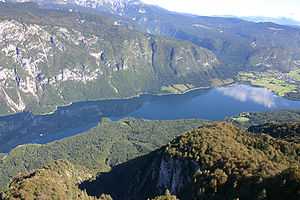
 Kolpa at Prelesje (Slovenia) | |
| Origin | Razloge, Gorski kotar, Croatia |
| Mouth | Sava, Sisak, Croatia |
| Basin countries | Croatia, Slovenia |
| Length | 297 km (185 mi)[1] |
| Source elevation | 313 metres (1,027 ft)[2] |
| Mouth elevation | 130 metres (430 ft)[2] |
| Avg. discharge | 283 m3/s |
| Basin area | 10,032 km2 |
The Kupa (Croatian) or Kolpa (Slovene, from Latin: Colapis in Roman times) river, a right tributary of the Sava, forms a natural border between north-west Croatia and southeast Slovenia. It is 297 kilometres (185 miles) long,[1] with its border part having a length of 118 km (73 mi)[2] and the rest located in Croatia.[3]
Course
The Kupa originates in Croatia in the mountainous region of Gorski Kotar, northeast of Rijeka, in the area of Risnjak National Park. It flows a few kilometers eastwards, receives the small Čabranka River from the left, before reaching the Slovenian border.
It then continues eastwards between the White Carniola region in the north and Central Croatia in the south. The Kupa receives influx from the river Lahinja from the left in Primostek, passes Vrbovsko, and eventually detaches from the Slovenian border having passed Metlika.
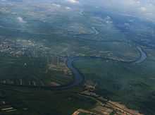
It then reaches the city of Karlovac, where it receives influx from two other rivers from the right, Dobra and Korana (which in turn is joined by Mrežnica). The Kupa continues flowing to the east, where it merges with Glina from the right as well as Odra from the left, and proceeds to the town of Sisak where it flows into the Sava River.
Pollution
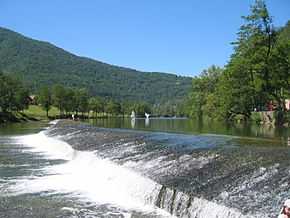
Fairly unpolluted downstream to Karlovac, the upper Kupa is a popular place for bathing in summer. The section from Stari Trg down to Fučkovci since 2006 is part of the Slovenian Krajinski park Kolpa nature reserve.
The hydrological parameters of the Kupa are regularly monitored at Radenci, Kamanje, Karlovac and Jamnička Kiselica.[4]
References
- ↑ 1.0 1.1 "Main Hydrographic Features in the Sava River Basin". Sava River Basis Analysis Report (PDF). Zagreb: International Sava River Basin Commission. September 2009. p. 13.
- ↑ 2.0 2.1 2.2 "Reke, dolge nad 25 km, in njihova padavinska območja" [Rivers, longer than 25 km, and their catchment areas] (in Slovene and English). Statistical Office of the Republic of Slovenia. 2002.
- ↑ Kolbezen, Marko; Pristov, Janko (1998). Površinski vodotoki in vodna bilanca Slovenije [Surface Streams and Water Balance of Slovenia] (PDF) (in Slovene and with an abstract in English). Hidrometeorološki inštitut RS [Hydrometeorological Institute of the Republic of Slovenia]. p. 8. ISBN 961-6024-04-3.
- ↑ "Daily hydrological report". Croatian Meteorological and Hydrological Service. Retrieved 2010-09-05.
External links
| Wikimedia Commons has media related to Kupa. |
- source of Kupa pictures
- Panoramic of the source
- Awarded "EDEN - European Destinations of Excellence" non traditional tourist destination 2010
Coordinates: 45°27′36″N 16°24′08″E / 45.46000°N 16.40222°E
| ||||||||||||||||||
| ||||||||||||||||||||||||||||||||||||