Kunlun fault
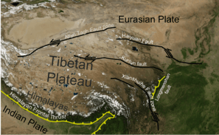
Tectonic map of the Tibetan Plateau showing location of the Kunlun fault
The Kunlun fault is a strike slip fault to the north side of Tibet. Slippage along the 1,500 kilometres (930 mi) long fault has occurred at a constant rate for the last 40,000 years. This has resulted in a cumulative offset of more than 400 metres (1,300 ft).[1] The fault is seismically active, most recently causing the magnitude 7.8 2001 Kunlun earthquake.[2]
References
- ↑ "The Kunlun Fault". Earth Observatory. NASA. 2000-10-10. Retrieved 2010-04-15.
- ↑ Klinger, Y.; Xu X., Taponnier P., Vand der Woierd J., Lasserre C. & King G. (2005). "High-Resolution Satellite Imagery Mapping of the Surface Rupture and Slip Distribution of the Mw ~7.8, 14 November 2001 Kokoxili Earthquake, Kunlun Fault, Northern Tibet, China". Bulletin of the Seismological Society of America 95 (5): 1970–1987. Bibcode:2005BuSSA..95.1970K. doi:10.1785/0120040233. Retrieved 15 June 2010.