Kunkunani
| Kunkunani | |
|---|---|
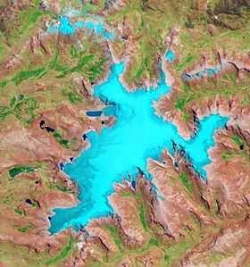 The glaciated area of Rit'ipampa with Kunkunani on the right (NASA, 2010) | |
| Elevation | 5,400 m (17,700 ft)[1] |
| Location | |
 Kunkunani Peru | |
| Location | Peru, Puno Region |
| Range | Andes, Willkanuta |
| Coordinates | 13°55′32″S 70°46′47″W / 13.92556°S 70.77972°WCoordinates: 13°55′32″S 70°46′47″W / 13.92556°S 70.77972°W |
Kunkunani (Aymara kunkuna a plant (Distichia muscoides),[2] -ni a suffix to indicate ownership, "the one with kunkuna", hispanicized spelling Cuncunani) is a mountain in the Willkanuta mountain range in the Andes of Peru, about 5,400 metres (17,717 ft) high. It is situated in the Puno Region, Carabaya Province, Corani District. Kunkunani lies in the east of the large glaciated area of Rit'ipampa (Quechua for "snow plain") and southeast of Khunurana.[1]
References
- ↑ 1.0 1.1 escale.minedu.gob.pe - UGEL map of the Carabaya Province (Puno Region)
- ↑ Jorge Araya-Presa, Francisco A. Squeo, Lina Barrientos, Eliana Belmonte, Manuel Mamani, Gina Arancio, Manual de Plantas y Canciones en Aymara, PROYECTO EXPLORA-CONICYT ED7/02/085: Etnobotánica y Etnomusicología Aymara: Divulgación de la sabiduría ancestral sobre plantas nativas del Altiplano de Arica, Chile, 2003