Kungsleden
| Kungsleden | |
|---|---|
|
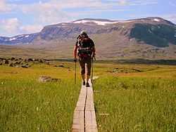
The Kungsleden trail between Alesjaure and Tjäktja huts | |
| Length | 440 kilometres (270 mi) approximately[1] |
| Location | Northern Sweden |
| Trailheads | Abisko/Hemavan |
| Use | Hiking |
| Elevation | |
| Highest point | Tjäktja Pass, 1,150 m (3,770 ft) |
| Lowest point | Kvikkjokk, 305 m (1,001 ft) |
| Hiking details | |
| Trail difficulty | Moderate |
| Season | Summer to early autumn |
| Months | June to September |
| Sights | Mt Kebnekaise, Lapporten, Abisko, Sarek National Park |
Kungsleden (The King's Trail) is a hiking trail in northern Sweden, approximately 440-kilometre (270 mi) long, between Abisko in the north and Hemavan in the south.[1] It passes through one of Europe's largest remaining wilderness areas. In the winter Kungsleden is a ski trail with approximately the same route.
The trail
Kungsleden was created by Svenska Turistföreningen (STF) at the end of the 19th century, in order to allow more people to experience the beauty of Lapland. It runs for about 440 kilometres (270 mi) between Abisko in the north and Hemavan in the south. The trail is well marked and many sections are well equipped and maintained by STF, with plank walkways covering swampy or rocky ground, but other sections further from the trailheads are eroded and rocky, increasing the difficulty of hiking some parts of the trail. There are bridges across non-fordable streams and during the summer season lakes and rivers could be crossed either with rowing boats provided by STF or by taking a local charter boat.
The trail is separated in four portions which each represent approximately one week of hiking. The most practiced part is by far the northernmost, between Abisko and Kebnekaise. The season, when the huts are open and rowing boats available, usually runs between mid-June and the end of September, but the weather can be very treacherous, including late or early snow. The winter season runs from mid February to the end of April.
Huts
Huts have been constructed along the trail, separated by a distance that a walker could expect to cover during the day, about 9-22 kilometres (6-14 mi). The huts are primarily operated by STF. For a small fee, it is possible to pitch a tent outside and use the facilities. Supplies can be bought in some of them (Alesjaure and Kebnekaise Fjällstation for example). Some emergency shelters can also be found on the route.
The huts along Kungsleden are:
|
|
|
There are no huts between Kvikkjokk and Ammarnäs which is about a 130 kilometres (81 mi) section of the Kungsleden.

Sights
Highlights along the way, sometimes a small detour is needed, are:
- Abisko: Hostel / mountain station, botanical multitude during summer, great back-country skiing during winter. From here, it's possible to get to Nikkaluokta via dog-sledging tours during the winter.
- Kebnekaise: Sweden's highest mountain, 2,111 metres (6,926 ft), and centre of Swedish alpinism, with the lodge (Kebnekaise Fjällstation) at its foot.
- Sarek National Park: part of Lappland world heritage. No roads, tracks or bridges makes this a terain for experienced hikers.
- Kvikkjokk: Old mountain farming village and nice hostel.
- Hemavan and Tärnaby: Small towns/villages with nice hiking possibilities in the summer, and excellent back-country skiing possibilities in the winter. Native village of alpine skier Ingemar Stenmark.
Getting there
You can get to Abisko by direct train from Göteborg, Stockholm or Narvik. Abisko can also be reached by bus either from Kiruna or from Narvik, which can be reached by regular air traffic. You can get to Hemavan by bus from Umeå or Mo i Rana in Norway. There are also regular, but not daily, flights between Hemavan and Stockholm.
A few places along the trail can be reached by road or public transport (a few others can also be reached by boat charter services). Some buses only run during the summer season.
- Nikkaluokta, about 33 kilometres (21 mi) of the trail and 20 kilometres (12 mi) from Kebnekaise can be reached by bus or car from Kiruna.
- Suorva and Kebnats can be reached by bus or car from Gällivare.
- Kvikkjokk can be reached by bus or car from Jokkmokk.
- Jäckvik (Jäkkvik) can be reached by bus or car from Umeå, Arvidsjaur or Fauske in Norway.
- Adolfström can be reached by bus or car from Arjeplog.
- Ammarnäs can be reached by bus or car from Sorsele.
During the summer Jokkmokk, Arvidsjaur and Sorsele are reachable by The Inland Line tourist railway.
References
- ↑ 1.0 1.1 "Kungsleden". Nationalencyklopedin (in Swedish). Retrieved 1 August 2010.
External links
| Wikimedia Commons has media related to Kungsleden. |