Kundapur
| Kundapur ಕುಂದಾಪುರ | |
|---|---|
|
| |
 Kundapur Town | |
| Coordinates: 13°48′N 74°42′E / 13.80°N 74.7°ECoordinates: 13°48′N 74°42′E / 13.80°N 74.7°E | |
| Country | India |
| State | Karnataka |
| Region | Kundapura karavali |
| District | Udupi |
| Zone | Kundapur, Karnataka |
| Municipality | Kundapur Town Municipal Council |
| Settled | 1912 |
| Headquarters | Udupi |
| Area | |
| • Total | 23.06 km2 (8.90 sq mi) |
| Elevation | 80 m (260 ft) |
| Population (2011[1]) | |
| • Total | 30,450 |
| • Density | 2,415.11/km2 (6,255.1/sq mi) |
| Languages | |
| • Official | Kannada |
| Time zone | IST (UTC+5:30) |
| PIN | 576 201 |
| Telephone code | 91-(0)8254 |
| Vehicle registration | KA-20 |
| Nearest city | Udupi, Byndoor, Mangalore |
| Sex ratio | 1.09 ♂/♀ |
| Legislature type | Bicameral |
| Lok Sabha constituency | Udupi Loksabha Constituency(15th) |
| Vidhan Sabha constituency | Kundapur Vidhansabha Kshethra(124th) |
| Website |
www |
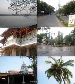
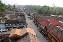
Kundapur is a coastal town in the Indian state of Karnataka. It is administered by Kundapur Town Municipal Council and the town is also a headquarters of Kundapur Taluk.
History

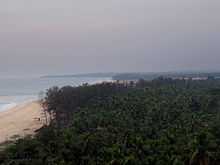


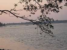
The name Kundapur can be traced to the Kundeshwar temple built by Kundavarma in the vicinity of the Panchagangavalli river. The name of the town may be derived from Kundavarma who ruled the area. Kunda means 'pillar' in Kannada,[2] which refers to the traditional method of constructing houses. Pura means town. Kundapur is surrounded by water from three sides. To the north lies the Panchagangavali river. To the east lies the Kalaghar river. To the west lie the Kodi back waters and the Arabian Sea, leaving the south side as the main connecting land mass. All connecting roads to Kundapur enter the city from southern direction. North side of the town is vast backwaters of Panchagangavali river and a bridge has been constructed across it .
Access
Kundapur is well connected to other parts of the country by NH66. This Highway connects cities and towns of different states as follows: Panvel, Mahad, Khed, Chiplun, Hatkhamba (Ratnagiri), Rajapur, Kankavali, Kudal, Sawantwadi, Panaji, Margao, Karwar, Kumta, Bhatkal, Kundapur, Udupi, Surathkal, Mangalore, Kasaragod, Taliparamba, Kannur, Thalassery, Vadakara, Kozhikkode, Kottakkal, Ponnani, Kodungallur, North Paravur and Edappally in Kochi.
The nearest airport is Mangalore International Airport, situated at Bajpe around 87 kilometres (54 mi) from Kundapur.
SH52 is the main State Highway that connects to Shimoga District. It has 84 km length and passes through Koni, Basrur, Kandlur, Siddapura, Hosangadi, Balebare, Nagara and Thirthahalli. Kundapur also has better connectivity to Malenadu (Chikamagalore District) via Karkala.
Kundapur is also connected to the Konkan Railway, which runs from Mumbai to Mangalore. The railway station is about 4 kilometres (2.5 mi) from the town.
Demographics
As of the 2001 India census,[3]
- Kundapur has a population of 30,450 .
- Males constitute 49% of the population and females 51%.
- Literacy rate of 92%, higher than the national average of 59.5%: male literacy is 94%, and female literacy is 88%.
- 9% of the population are under 6 years of age.
.
Communities, languages and culture
The town consists mainly of Hindus of many communities such as Shettigars,Sherigars,Kotegars, Vishwakarmas, poojarys, Kota Brahmins, Havyaka Brahmins, Shivalli Brahmins, Goud Saraswat Brahmins, Mogaveeras, Kulals, Bunts, Vokkaligas, Devadigas, Billavas Namadhari Naiks, Ganigas, Ramakshatriyas, Daivajnas, Kunabis, Chitrapur Saraswat Brahmins, Kharvis, Christians and Muslims.
The town mainly consists of Kannadigas who speak Kundagannada (82%). Others are Konkanis (12%) and Tuluvas. The Goud Saraswat Brahmins, the Kharvi community, the Christian community and some Muslim community people speak Konkani Language. A dialect of Kannada called Kundaganna or Kundapur Kannada is predominantly spoken in Kundapur town and Kundapur Taluk. Tulu is also spoken by some people (By 5% of the Population of Kundapur). Though most of The Tuluvas are from Mangalore and Udupi city.
In the olden days, Tulu language was widely spoken in the region and the historical town of Barkur served as the capital city of Tulunadu.
References
| Wikimedia Commons has media related to Kundapura. |
- ↑ http://www.kundapurtown.gov.in/
- ↑ Kittel, Ferdinand (1999). A Kannada-English dictionary. Asian Educational Services. p. 441. ISBN 81-206-0049-5.
- ↑ "Census of India 2001: Data from the 2001 Census, including cities, villages and towns (Provisional)". Census Commission of India. Archived from the original on 2004-06-16. Retrieved 2008-11-01.
| ||||||||||||||||||||||||||