Kumgang County
| Kumgang County 금강군 | |
|---|---|
| County | |
| Korean transcription(s) | |
| • Chosŏn'gŭl | 금강군 |
| • Hancha | 金剛郡 |
| • McCune-Reischauer | Kŭmgang kun |
| • Revised Romanization | Geumgang-gun |
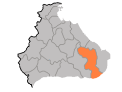 | |
| Country | North Korea |
| Province | Kangwon Province |
| Administrative divisions | 1 ŭp, 23 ri |
| Area | |
| • Total | 1,009 km2 (390 sq mi) |
| Population (1991 est.) | |
| • Total | 100,000 |
Kumgang County is a kun, or county, in Kangwon province, North Korea. Kumgang lies immediately north of the Korean Demilitarized Zone. It was formed in 1952 from portions of Hoeyang, Yanggu, and Inje, as part of a general reorganization of local government, and stretches out from north to south. The county takes its name from the Kumgang mountain, which is partially located there.
The Taebaek Mountains pass through the county, reaching their highest point in the Pirobong peak of Kumgangsan. Approximately 85% of the county's area is forestland. Major local streams include the Kumgangchon and Dongkumgangchon.
The chief local industry is agriculture, with rice and maize the dominant crops. However, arable land takes up only 8.5% of the county's area. Manufacturing and livestock raising also contribute to the local economy. Mining is supported by deposits of gold, tungsten, and quartz.
See also
- Geography of North Korea
- Administrative divisions of North Korea
- Kangwon (North Korea)
- Kumgangsan
External links
- (Korean) In Korean language online encyclopedias:
| ||||||||||||||||