Kukaniloko Birth Site
|
Kukaniloko Birth Site | |
 | |
|
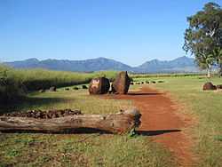
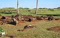
View from park entrance toward Kolekole Pass | |
 | |
| Nearest city | Wahiawa, Hawaii |
|---|---|
| Coordinates | 21°30′28″N 158°2′22″W / 21.50778°N 158.03944°WCoordinates: 21°30′28″N 158°2′22″W / 21.50778°N 158.03944°W |
| Area | 5 acres (2.0 hectares) |
| Built | prior to the 13th century |
| Architectural style | Ancient Hawaiian |
| Governing body | Public |
| NRHP Reference # | 73000674 and 94001640[1] |
| Added to NRHP | April 11, 1973 (original) and February 09, 1995 (increase) |
Kūkaniloko Birth Site, also known as the Kūkaniloko Birthstones State Monument, is one of the most important ancient cultural sites on the island of Oʻahu. It was first listed on the National Register of Historic Places in 1973 and its boundaries were increased in 1995,[1] after 5 acres (2.0 ha) of land including it became a State park in 1992.[2]
Geography
Kūkaniloko lies in the Wahiawā Plateau between Oʻahu's two mountain ranges: the Waiʻanaes to leeward, and the Koʻolaus to windward. It also lies at the intersection of two major paths of overland travel: the Waialua Trail between the North Shore and 'Ewa Beach, and the Kolekole Trail through the Waiʻanae Range.[2]
The present day location is near the intersection of Kamehameha Highway and Whitmore Avenue just north of Wahiawā, Hawaiʻi.
History
As the geographic piko (navel) of Oʻahu, Kūkaniloko was symbolically the most powerful birth site for the island's high chiefs, among whom Kakuhihewa and Kualii were perhaps most famous. The Hoʻolonopahu Heiau associated with the site was later destroyed, as were many others in the area, to make room for sugarcane and pineapple fields in the rich soils where sweet potato and yam once grew in abundance. Chiefly families lived along the slopes of the Waiʻanaes overlooking the plateau and along the shores of Waialua to the north, and many key battles between rivals for control of Oʻahu were also fought on the central plains surrounding Kūkaniloko.[2]
The wide view of the skies from Kūkaniloko might also have made it a sort of Hawaiian Stonehenge.[3] In April 2000, a team from the University of Hawaiʻi Institute for Astronomy recorded designs and shapes on the stones that could have been used to track the movements of celestial objects for calendrical purposes.[4]
Gallery
-
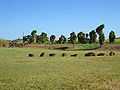
View from entrance stones to central stones
-
Ki plants on raised earth platform
-

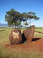
Shape of northern Waiʻanae Range
-

Central stones and coconut palms
-
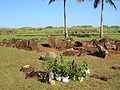
Plant offerings at central stones
-
Corrugated central stone
References
- ↑ 1.0 1.1 "National Register Information System". National Register of Historic Places. National Park Service. 2008-04-15.
- ↑ 2.0 2.1 2.2 "Hawaii State Parks: Oahu: Kukaniloko Birthstones State Historic Site". official web site. Hawai'i Department of Land and Natural Resources. Retrieved 2010-02-05.
- ↑ "Kukaniloko - a Hawaiian Stonehenge?". Retrieved 2009-12-28.
- ↑ "Kukaniloko Visit 4/12/00". University of Hawaii Institute for Astronomy. Retrieved 2009-12-28.
External links
| ||||||||||||||||||||||||||