Kuchinoerabu-jima
| Native name: <span class="nickname" ">Japanese: 口永良部島 | |
|---|---|
 Kuchinoerabu-jima from Nagatadake on Yakushima | |
 | |
| Geography | |
| Location | East China Sea |
| Coordinates | 30°28′N 131°11′E / 30.467°N 131.183°E |
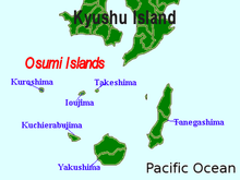
| Archipelago | Osumi Islands |
| Area | 38.04 km2 (14.69 sq mi) |
| Length | 12 km (7.5 mi) |
| Width | 5 km (3.1 mi) |
| Coastline | 49.67 km (30.864 mi) |
| Highest elevation | 657 m (2,156 ft) |
| Highest point | Furudake |
| Country | |
|
Japan | |
| Kagoshima Prefecture | |
| Demographics | |
| Population | 147 (as of 2010) |
| Ethnic groups | Japanese |
.jpg)
Kuchinoerabu-jima (口永良部島), is one of the Satsunan Islands, usually classed with the Ōsumi Islands belonging to Kagoshima Prefecture, Japan. The island, 38.04 km² in area, has a population of 147 persons. The island can only be reached by boat as it has no airport. There are regular ferry service with Yakushima, which is about 15 km to the east. Travel time is approximately 1 hour. The islanders are dependent mainly on fishing, agriculture and seasonal tourism. The entire island is within the borders of the Kirishima-Yaku National Park.
Geography
Kuchinoerabu-jima is located 130 kilometres (70 nmi) south of Kagoshima. The island is of volcanic origin, and has an area of approximately 38 square kilometres (15 sq mi) with a length of 12 kilometres (7.5 mi) and width of 5 kilometres (3.1 mi). The highest elevations on the island are Furudake (古岳), with a height of 657 metres (2,156 ft) and Shindake (新岳), with a height of 640 metres (2,100 ft) above sea level. There are numerous hot springs on the island.
The island is an active volcano which has erupted several times during the modern period, including 24 December 1933, when several people were killed when lava masses buried several villages. In 1980, multiple explosion craters appeared along an 800-metre (2,600 ft) north-south fissure on the slope east of Shindake. Shindake erupted again on 4 August 2014, generating a pyroclastic flow, but with no injuries or fatalities.[1]
The island’s climate is classified as subtropical, with a rainy season from May through September.
History
During the Edo period, Kuchinoerabu-jima was ruled by the Shimazu clan of Satsuma Domain and was considered part of Ōsumi Province. Following the Meiji restoration, it was administered as Kuchinoerabujima Village, which encompassed part of Yakushima. It is now part of the city of Yakushima, Kagoshima.
Kuchinoerabu-jima is the last known location of missing American poet Craig Arnold, who was visiting the island in April 2009, doing research for a book on volcanos.[2]
References
- Siebert, Lee. Volcanoes of the World. University of California Press. (2008) ISBN 0520268777
- Reed, Christina. Earth Science Decade by Decade. Infobase Publishing (2008) ISBN 0816055335
External links
| Wikimedia Commons has media related to Kuchinoerabujima. |
- "Kuchinoerabu-jima". Global Volcanism Program. Smithsonian Institution.
- "Kuchinoerabu Island Volcano Satellite Images". The ASTER Volcano Archive. Jet Propulsion Laboratory. Retrieved 2009-06-15.
- Geshi, Nobuo; Tetsuo Kobayashi (2006). "Volcanic Activities of Kuchinoerabujima Volcano within the Last 30,000 Years". Bulletin of the Volcanological Society of Japan (in Japanese) (Japan) 51 (1): 1–20. ISSN 0453-4360.
- Saito, Eiji; Masato Iguchi (2006). "Ground Deformation Detection at Kuchinoerabujima Volcano by Continuous GPS with Simple Atmospheric Correction". Bulletin of the Volcanological Society of Japan (in Japanese) (Japan) 51 (1): 21–30. ISSN 0453-4360.
- Triastuty, Hetty; Masato Iguchi; Takeshi Tameguri; Tomoya Yamazaki. "Hypocenters, Spectral Analysis and Source Mechanism of Volcanic Earthquakes at Kuchinoerabujima: High-frequency, Low-frequency and Monochromatic Events". Sakurajima Volcano Research Center, DPRI, Kyoto University. Retrieved 2009-06-15.
- Official home page
Notes
- ↑ Volcano Discovery site
- ↑ "US poet missing on Japan volcano". BBC News. 1 May 2009.
| ||||||||||||||||||||||