Krumegg
| Krumegg | ||
|---|---|---|
| ||
 Krumegg Location within Austria | ||
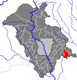
Location within Graz-Umgebung district
| ||
| Coordinates: 47°01′13″N 15°38′02″E / 47.02028°N 15.63389°ECoordinates: 47°01′13″N 15°38′02″E / 47.02028°N 15.63389°E | ||
| Country | Austria | |
| State | Styria | |
| District | Graz-Umgebung | |
| Government | ||
| • Mayor | Josef Hierzer (GL) | |
| Area | ||
| • Total | 16.19 km2 (6.25 sq mi) | |
| Elevation | 463 m (1,519 ft) | |
| Population (1 January 2014)[1] | ||
| • Total | 1,450 | |
| • Density | 90/km2 (230/sq mi) | |
| Time zone | CET (UTC+1) | |
| • Summer (DST) | CEST (UTC+2) | |
| Postal codes | 8323, 8301 | |
| Area codes | 03133, 03119 | |
| Vehicle registration | GU | |
| Website |
www.krumegg. steiermark.at | |
Krumegg is a municipality in the district of Graz-Umgebung in the Austrian state of Styria.
Geography
Krumegg lies about 15 km east of Graz in the east Styrian hills.
Subdivisions
Katastralgemeinden are Brunn, Dornegg, Kocheregg, Hohenegg, Prüfing, Kohldorf, Pirkwiesen, and Krumegg-Ort.
Neighboring municipalities
| Edelsgrub | Nestelbach bei Graz | Langegg bei Graz |
| Edelsgrub | 
| Sankt Marein bei Graz |
| Empersdorf | Pirching am Traubenberg, Edelstauden | Petersdorf II |

