Krimpenerwaard
| Krimpenerwaard | |
|---|---|
| Municipality | |
|
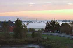
Krimpenerwaard landscape on an October morning in 2009 | |
 Location in South Holland | |
| Coordinates: 51°59′N 4°47′E / 51.983°N 4.783°ECoordinates: 51°59′N 4°47′E / 51.983°N 4.783°E | |
| Country | Netherlands |
| Province | South Holland |
| Government | |
| • Body | Municipal council |
| • Mayor | Tjerk Bruinsma (acting) |
| Time zone | CET (UTC+1) |
| • Summer (DST) | CEST (UTC+2) |
| Area code | 0180/0182 |
| Website |
www |


Krimpenerwaard is a municipality of the Netherlands. It is a rural area located in the east of the province of South Holland, just south of Gouda and east of the Rotterdam conurbation. It is bordered on the north by the river Hollandse IJssel, on the south by the river Lek and on the east by the stream Vlist.[1]
Krimpenerwaard obtains its name from the town located in its western corner, Krimpen aan den IJssel. ("Krimp" used to mean a bend in a river.) "Waard" is the Dutch word for an interfluvial area between the winter dikes of different river channels (in this case, the Lek and the Hollandse IJssel).[2] There are other such waarden in this area. The Lopikerwaard lies to the east; the Zuidplaspolder to the west. The name Krimpenerwaard first appeared in the historical records in 944.
The municipality was formed by a merger of the municipalities of Nederlek, Ouderkerk, Vlist, Bergambacht and Schoonhoven on 1 January 2015.[3]
Geography
The towns and villages in the Krimpenerwaard are:
- Schoonhoven
- Bergambacht
- Stolwijk
- Ammerstol
- Haastrecht
- Berkenwoude
- Lekkerkerk
- Krimpen aan de Lek
- Vlist
- Gouderak
- Ouderkerk aan den IJssel
Notes
- ↑ This is a translation of the article by the same name on the Dutch version of Wikipedia.
- ↑ http://adsabs.harvard.edu/full/1996ESASP.383..469W Wang, Y., Koopmans, B. N., & Pohl, C., "The 1995 Flood in the Netherlands Monitored from Space - a Multisensor Approach"
- ↑ "Herindeling vijf gemeenten Krimpenerwaard". Binnenlands Bestuur (in Dutch). Retrieved 3 January 2015.
External links
- Nieko Jongerius's website on the Krimpenerwaard
- Map of Krimpenerwaard on Google Maps
- English page on the website for the The Schieland en de Krimpenerwaard District Water Board
