Kouchibouguac National Park
| Kouchibouguac National Park Parc national de Kouchibouguac (French) | |
|---|---|
|
IUCN category II (national park) | |
|
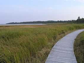
Boardwalk over a salt marsh | |
 Location of Kouchibouguac National Park in Canada | |
| Location | Kent County, New Brunswick, Canada |
| Nearest city | Miramichi, New Brunswick |
| Coordinates | 46°50′59″N 64°58′01″W / 46.84972°N 64.96694°WCoordinates: 46°50′59″N 64°58′01″W / 46.84972°N 64.96694°W |
| Area | 238 km2 (92 sq mi) |
| Established | 1969 |
| Governing body | Parks Canada |
Kouchibouguac National Park is located on the east coast of New Brunswick, in Kouchibouguac. The park includes barrier islands, sand dunes, lagoons, salt marshes and forests. It provides habitat for seabirds, including the endangered Piping Plover, and the second largest tern colony in North America. Colonies of harbour seals and grey seals also inhabit the park's 25 kilometres (16 mi) of sand dunes. It is also home to the extremely rare and fragile Gulf of St. Lawrence Aster, though in 2006, storms eradicated most of the asters' colonies. The park's size is 238 square kilometres (92 sq mi). Recreational activities in the park include swimming, cycling and hiking. In recent news, the park has reported sightings of the fisher marten in the area, making it one of the few places in New Brunswick that have fisher populations.The one thing that seems to attract many visitors are the activities. Kouchibouguac [pronounced koo-chi-bu-gwac] has many activities ranging from a river adventure in a war canoe to going seal watching to a talk about Mi'kmaq people.
History
The park was founded in 1969 in order to set aside sensitive sand dunes and bogs. While it was developed in the 1970s, Parks Canada encountered great difficulty expropriating land from numerous land owners (approximately 215 families, including over 1200 individuals). The residents were generally seen as so poor that government officials believed they would benefit from having to start their lives again elsewhere. Government officials believed that they were rehabilitating the people by forcing them to move. The most notable of these was Jackie Vautour, whose home was buldozed in 1976, but who returned to squat there two years later, where he still remains.[1]
Kelly's Beach, a very long sand dune, is a popular attraction along with a number of bogs, a boardwalk trail, eight hiking trails, a network of bicycle trails, two campgrounds, canoe and boat launch and the Cap-St-Louis fishing port. Kelly's Beach is popular with naturists as the long sandy beach allows privacy and seclusion.
The park is named after the Kouchibouguac River. The river's name means "river of the long tides" in Mi'kmaq.
Other rivers that flow through the park include the:
- Black River
- Kouchibouguacis River
- Saint-Louis River
- Portage River
The story of the park had been the subject of two big budget documentaries. In addition, the park was the subject of a short film in 2011's National Parks Project, directed by Jamie Travis and scored by Casey Mecija, Don Kerr and Ohad Benchetrit. There is also a website which provides access to 26 video portraits of the people removed from their land as part of the process of creating the park.[2]
Gallery
-
Kouchibouguac Park
-
.jpg)
Bilingual sign on the property of Jackie Vautour in the park along the Kouchibouguac River
See also
- National Parks of Canada
- List of parks in New Brunswick
- List of trails in New Brunswick
- List of beaches in New Brunswick
References
- ↑ Ronald Rudin, "Kouchibouguac: Representations of a Park in Acadian Popular Culture," in Claire Campbell, ed., 'A Century of Parks Canada' (University of Calgary Press, 2011), pp 205-33.
- ↑ Returning the Voices to Kouchibouguac National Park. Returningthevoices.ca. Retrieved on 2013-08-09.
| Wikimedia Commons has media related to Kouchibouguac National Park. |
| ||||||||||||||||||||||||||
| ||||||||||||||||||||||||||

