Kosuge, Yamanashi
| Kosuge 小菅村 | |||
|---|---|---|---|
| Village | |||
|
View of Kosuge Village | |||
| |||
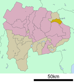 Location of Kosuge in Yamanashi Prefecture | |||
 Kosuge
| |||
| Coordinates: 35°46′N 138°56′E / 35.767°N 138.933°ECoordinates: 35°46′N 138°56′E / 35.767°N 138.933°E | |||
| Country | Japan | ||
| Region |
Chūbu Tōkai | ||
| Prefecture | Yamanashi Prefecture | ||
| District | Kitatsuru | ||
| Area | |||
| • Total | 52.65 km2 (20.33 sq mi) | ||
| Population (July 1, 2012) | |||
| • Total | 1,865 | ||
| • Density | 23.4/km2 (61/sq mi) | ||
| Time zone | Japan Standard Time (UTC+9) | ||
| Phone number | 0428-87-0111 | ||
| Address | 4698 Kosuke-mura, Kitatsuru-gun, Yamanashi 409-0211 | ||
| Website |
www | ||
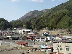


Kosuge (小菅村 Kosuge-mura) is a village located in Kitatsuru District, Yamanashi Prefecture, Japan. As of July 2012, the village has an estimated population of 769 and a population density of 14.6 persons per km². The total area was 52.65 km².
Geography
Kosuge is located in the mountainous far northeastern corner of Yamanashi Prefecture. Much of the land in the village is protected watershed forest within the Chichibu Tama Kai National Park, providing water for the Tokyo Metropolis.
Neighboring municipalities
Yamanashi Prefecture
- Uenohara
- Otsuki
- Kofu
- Tabayama
Tokyo Metropolis
History
During the Edo period, all of Kai Province was tenryō territory under direct control of the Tokugawa shogunate. During the cadastral reform of the early Meiji period in July 1, 1889, the village of Kosuke was created within Kitatsuru District, Yamanashi Prefecture.
Economy
The economy of Kosuke is primarily based on forestry and agriculture.
Transportation
Highway
External links
![]() Media related to Kosuge, Yamanashi at Wikimedia Commons
Media related to Kosuge, Yamanashi at Wikimedia Commons
- Kosuge official website (Japanese)
| ||||||||||||||||||||||||||||