Korea, Kentucky
| Korea | |
|---|---|
| Unincorporated community | |
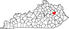
 Korea Location within the state of Kentucky | |
| Coordinates: 37°56′31″N 83°28′43″W / 37.94194°N 83.47861°WCoordinates: 37°56′31″N 83°28′43″W / 37.94194°N 83.47861°W | |
| Country | United States |
| State | Kentucky |
| County | Menifee |
| Elevation | 1,118 ft (341 m) |
| Time zone | Eastern (EST) (UTC-5) |
| • Summer (DST) | EDT (UTC-4) |
| ZIP codes | 40340 |
| GNIS feature ID | 513178 |
Korea is an unincorporated community in Menifee County, Kentucky, United States. It lies along Route 1693 east of the city of Frenchburg, the county seat of Menifee County.[1] Its elevation is 1,119 feet (341 m).[2] Their post office closed in February 1982 [3]
Korea is part of the Mount Sterling Micropolitan Statistical Area.
References
- ↑ Rand McNally. The Road Atlas '06. Chicago: Rand McNally, 2006, p. 43.
- ↑ U.S. Geological Survey Geographic Names Information System: Korea, Kentucky, Geographic Names Information System, 1979-09-20. Accessed 2008-01-03.
- ↑ http://webpmt.usps.gov/pmt011.cfm
| |||||||||||||||||