Korangal Valley
Korangal Valley is a valley in north-eastern Afghanistan that was the scene of fierce fighting between ISAF's Eastern Command consisting mostly of US forces and insurgents in Afghanistan—referred to as "Anti-Afghanistan Forces" (AAF) or "Anti-Coalition Militia" (ACM)—notably the Taliban.
Army Special Forces and Rangers had conducted an unknown number of operations there prior to October 2004 when 3rd Battalion 6th Marines became the first Marine unit to begin operations there, followed by 3rd Battalion 3rd Marines the next month.[1] In the fall of 2005, the US Marines of 2nd Battalion 3rd Marines Echo Company conducted a 28-day foot patrol beginning at the backside of the valley, not only making them the farthest occupying force in that area to date but also claiming the longest completed foot patrol since Vietnam. Later Ed Darack wrote the book Victory Point, documenting two operations that the 2nd Battalion 3rd Marines conducted in the area, including the Korangal Valley, Operation Red Wings, and Operation Whalers.[2]
The Korangal Outpost was established at an abandoned lumber yard in April 2006 by Task Force Lava of 1st Battalion 3rd Marines and subsequently transferred to Alpha Company, 1-32 Infantry, 10th Mountain Division. Firebase Phoenix (later called Firebase Vimoto) was established in the village of Babeyal in the spring of 2007 by 2nd Platoon, A Company, 1-32d Infantry, 10th Mountain Division to act as a security buffer between the villagers and active anti-coalition militia (ACM) fighters in the valley.
After years of sustained fighting and casualties with little evident progress, the US military closed Korangal Outpost on April 14, 2010, after which the valley reverted to Taliban control,[3] but later re-opened it in June 2011 due to the growing problems with the AAF and ACM. Forty-two American service men died fighting in the Korangal and hundreds were wounded, primarily between 2006 and 2009. Many Afghan soldiers died there as well. The valley has been dubbed "The Valley of Death" by American forces.[4]
Professional British photographer Tim Hetherington won the World Press Photo award for 2007 with a shot he took while reporting on the war in Korangal valley for Vanity Fair magazine in January 2008.[5] Sebastian Junger's (2010) book War, and the subsequent film Restrepo, document his experiences while embedded with a US Army company manning the small Outpost Restrepo, named for a fallen comrade, in the Korangal valley.
Other spellings
Korengal, Kurangal, Korangal کړنګل کوړنګل کوړينګل
Villages
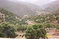
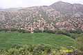
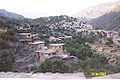
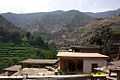
The valley includes more than a dozen villages:
| Ali Abad, Kunar (Elabat) |
|
| Ashat, Kunar | |
| Bebiyal, Kunar |
|
| Darbat, Kunar | |
| Donga, Kunar | |
| Landigal, Kunar |
|
| Landigal, Kunar |
|
| Hendarok lower, Kunar | |
| Hendarok upper, Kunar |
|
| Kandalik, Kunar | |
| Chechal, Kunar |
|
| Dakalbat, Kunar | |
| Seipale, Kunar | |
| Yakha China, Kunar | |
| Kandalam, Kunar | |
| Old Korangal, Kunar |
|


%2C_Kunar%2C_Afghanistan.jpg)

Including a few villages of Qalai-Gal-Valley
Tribes
The valley has six major tribes:
- Baba Khel
- Ghasu Khel
- Langer Khel
- Malik Khel
- Mutiara Khel
- Kathee Khel
The Korangalies are Pashai. Their native language is Pashayi but many are fluent in Pashto because the Safi tribe, a Pashtun people, live around them and they have some integration with this tribe.
Agriculture and forestry

The valley has rocky mountains with limited agricultural land. The Korangal valley is lushly forested with pine trees. Much of the valley's income is due to legal and illegal forestry and timber sales. In 2006, U.S. military and the government of Afghanistan reclaimed the Lumber Yard and established the first government presence in the valley since the 1980s. The Afghan government is working to find ways to boost the economy of the region so that illegal timbering come to an end. In the meantime, the local people of Kunar province are being trained to plant new trees to prevent deforestation.
See also
- Valleys of Afghanistan
- Operation Rock Avalanche
- Death of Linda Norgrove
- Restrepo (Documentary film)
References
- ↑ First into the Korengal?
- ↑ Darack 2009
- ↑ Video on YouTube
- ↑ http://www.nytimes.com/2010/04/15/world/asia/15outpost.html?hp New York Times. "U.S. Forces Close Outpost in Afghan 'Valley of Death'". Retrieved April 14, 2010.
- ↑ Vanity Fair article
Bibliography
- Darack, Ed (2009). Victory Point: Operations Red Wings and Whalers – The Marine Corps' Battle for Freedom in Afghanistan. Berkley Hardcover. ISBN 0-425-22619-0.
External links
| Wikimedia Commons has media related to Korengal Valley. |
- http://www.flickr.com/photos/korengal_valley/537234765/
- Afghanistan – Korengal Valley. Battle Company Is Out There. New York Times, February 24, 2008
- Afghanistan's Korengal Valley. 31 photos. November 12, 2008. Boston.com (Boston Globe).
- msnbc.com video: Under fire from Afghanistan’s frontlines:. 4 videos. October 2008. MSNBC. October 20, 2008 introduction and discussion: Confronting Afghanistan's 'Valley of Death'.
- GRITtv Interview With Laura Flanders and Tim Hetherington on "Restrepo"
- Wikimapia-Location of the Korangal Valley
- Panoramio-Location of Korangal Outpost (The KOP)
Coordinates: 34°52′52″N 70°54′19″E / 34.881231°N 70.905161°E