Koonung Creek Trail
 | |
|---|---|
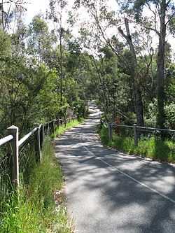
| The Koonung Creek Trail west of Blackburn Road. | |
| Koonung Creek Trail | |
| Length | 13.5km |
| Difficulty | Easy |
| Hills | Some minor hilly sections |
| Path | Concrete and bitumen |
| Connecting Transport | |
| Train | None |
The Koonung Creek Trail is a shared use path for cyclists and pedestrians, which follows Koonung Creek in the eastern suburbs of Melbourne, Victoria, Australia.[1][2][3][4] The trail also follows the course of the Eastern Freeway as it too, follows the course of the Koonung Creek, and has good connections to on-road paths.
Following the Path
The path is easy to follow as it travels parallel to the Eastern Freeway. 600m west of Middleborough Rd the trail is located on the south side of the freeway. East of that point it runs along the north side of the freeway.
Near the Bushy Creek Trail turnoff is a small wetland area with Purple Swamphens and the occasional Little Pied Cormorant. Koonung Creek Reserve also contains a small wetland which contains some native wildlife.
Connections
Yarra River Trail in the west. Intersects the Bushy Creek Trail in the middle. Since the completion of the EastLink project (2008), the trail links to the Mullum Mullum Creek Trail in the east, just 80m west of Beckett Rd.
Leaving the trail at Middleborough Rd and travelling north 1.9 km by road, leads to the Ruffey Creek Trail near George St. Leaving the trail at Middleborough Rd and travelling south 1.4 km by road, leads to the Bushy Creek Trail via Springfield Rd.
West end at 37°46′54″S 145°03′44″E / 37.781635°S 145.062340°E. East end at 37°48′15″S 145°12′16″E / 37.804200°S 145.204411°E.
References
- Bike rides around Melbourne 3rd edition, 2009, Julia Blunden, Open Spaces Publishing, ISBN 978-0-9752333-4-4
 Geographic data related to Koonung Creek Trail at OpenStreetMap
| ||||||||||