Kongola Constituency
Zambezi Region Constituencies
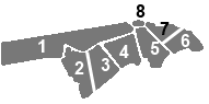
1 = Kongola
1 = Kongola
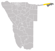
Kongola Constituency within Zambezi Region
Kongola is the westernmost constituency of Zambezi Region of Namibia, and the largest by area. It is located near the Kwando River. It contains the district village of Kongola and the villages of Mwanzi, Izwi, Mulanga, Pipo, Munguza, Kahunikwa, Poca, Queensland, Kakuwa, Mitondo, Nxtohei, and Kachenje.[1] Its population was 7,366 at the Census of Population 2011-08-28.[2]
The area is populated by members of the Mafwe and Mashi tribes, and thus governed by two traditional authorities.[3]
References
- ↑ Electoral Commission of Namibia: Presidential and National Assembly Elections 2009, Polling Stations. Supplement to several Namibian newspapers, 10 November 2009
- ↑ Statoids: Namibia, Constituencies
- ↑ Sanzila, George (24 October 2012). "Hostel tug-of-war". New Era. Archived from the original on 25 October 2012.
| ||||||||