Kokstad
| Kokstad | |
|---|---|
|
Kokstad City Hall and Victorian Bandstand. Also visible is the Memorial to Cape Mounted Riflemen & Volunteers, East Griqualand. 1899 -1902. | |
 Kokstad
| |
| Coordinates: 30°33′14″S 29°25′37″E / 30.55389°S 29.42694°ECoordinates: 30°33′14″S 29°25′37″E / 30.55389°S 29.42694°E | |
| Country | South Africa |
| Province | KwaZulu-Natal |
| District | Sisonke |
| Municipality | Greater Kokstad |
| Established | 1869 |
| Area[1] | |
| • Total | 51.57 km2 (19.91 sq mi) |
| Elevation | 1,302 m (4,272 ft) |
| Population (2011)[1] | |
| • Total | 51,561 |
| • Density | 1,000/km2 (2,600/sq mi) |
| Racial makeup (2011)[1] | |
| • Black African | 87.4% |
| • Coloured | 8.9% |
| • Indian/Asian | 1.3% |
| • White | 2.1% |
| • Other | 0.3% |
| First languages (2011)[1] | |
| • Xhosa | 72.9% |
| • English | 9.1% |
| • Afrikaans | 6.8% |
| • Zulu | 5.8% |
| • Other | 5.5% |
| Postal code (street) | 4700 |
| PO box | 4700 |
| Area code | 039 |
._Also_Memorial_to_Cape_Mounted_Riflemen_%26_Volunteers%2C_East_Griqualand._1899_-1902._03.jpg)
Kokstad is a town in the Sisonke District of KwaZulu-Natal Province, South Africa. Kokstad is named after the Griqua chief Adam Kok III who settled here in 1863. Stad is the Dutch and Afrikaans word for city.
The town is built on the outer slopes of the Drakensberg and is 1,302 m above the sea level. Behind it Mount Currie rises to a height of 2,224 m. It is a centre for cheese and other dairy products.
Kokstad is currently the fastest growing town in KwaZulu-Natal, with approximately 50,000 people residing there.
History
In 1820 the Griqua tribe which lived in Griquatown (in central South Africa) split and under the leadership of Adam Kok III, descendant of the ex-cook who established the tribe, one section first moved to Philippolis (southern Free State). In 1861 several hundred Griquas moved across the Drakensberg down the Ongeluks Nek to the vicinity of modern Kokstad. They moved because of the growing confrontation they faced with the Voortrekkers who had moved north of the Orange River to escape the laws of the British. The Voortrekkers, largely Dutch, secured leases over Griqua land and then refused to return the land at the end of the lease. The big hole of Kimberley was at the centre of controversy over one such lease.
The Griquas were forced to travel over the Drakensberg into a region earlier decimated by the great Zulu King, Chaka—thus its name "Nomansland". By the time the Griquas arrived in their new promised land eighteen months later they were exhausted and most of their livestock had perished. The impoverished Griquas named the mountain where they settled Mount Currie after Sir Walter Currie who gave support to their effort to settle here. Once settled their leader, Adam Kok, renamed their new land East Griqualand. Every male Griqua who settled in East Griqualand was able to secure a 3,000 acre (12 km²) farm, but most of them sold their land cheaply to white settlers and squandered their money.
When, in 1869, the Reverend William Dower was asked by the Griqua to establish a mission, he agreed on condition that they resettle in a more suitable place on the banks of the Mzimhlava river.
Two prominent European settlers George Brisley and Donald Strachan played a major role in the early development of Kokstad and East Griqualand: their trading store, Strachan and Co, introduced South Africa's first indigenous currency—a set of trade tokens which circulated across a wide region, covering an area the size of Ireland.
In 1874 East Griqualand came into the possession of Cape Colony. The first hotel in Kokstad, The Royal, was opened by an African-American who also started a newspaper (the Kokstad Advertiser) in 1881. Kokstad became a municipality in 1892. In 1904 the population was recorded at 2903 whom a third were Griquas. Today the population of Kokstad lies at just over 50,000 people.[2]
Cultural Assets
Stemming from a relatively old farming community, Kokstad rose from the lands beneath Mount Currie. Many old buildings and monuments have been erected that are now considered to be National Heritage Sites.
- The Adam Hoek Monument (Griqua): The Monument commemorates the leadership of the Griqua, Adam Kok, who, after leading the Griquas from the Southern Free State to Griqualand East during the 1860s, died after a fall off a cart in 1875. The Monument is situated next to the police station of Kokstad.[3]
- Adam Kok's laager (Griqua): In 1861, 2000 Griquas under Adam Kok migrated to the area from the Southern Free State.They lived in a laager in this vicinity for about ten years, before moving to Kokstad itself.They also took possession of a large number of farms which had been laid out for them. The site of their laager is marked by a Monument, which is situated in the foothills of Mount Currie.[4]
- Kokstad Bandstand (British Colonial): The ornamental, cast iron bandstand dates from 1912. It was donated to the town council by the engineers who were responsible for the Kokstad water scheme. It was declared a national monument in October 1983.[5]
- Boy Scouts Monument (Brititsh Monument): The Monument to former Boys Scouts who fell in the world wars is situated in the foothills of Mount Currie North of Kokstad.[6]
- Cape Mounted Rifles Monument (British Colonial): The Monument to the Cape Mounted Rifles is a tall column surrounded by four lions peering upwards. It is situated close to the town hall.[7]
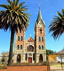
- St. Anthony's Catholic Church (Cathedral)
- East Griqualand Museum And Community Tourism Info Center: Griqua history is the main theme of this museums display. Although it has several other local history exhibits and items also known as the Kokstad museum.[8]
- Old Town Hall (Historical building): The Old town hall is considered a National Monument Site. It is one of the largest town structures that predates WWI within the surrounding areas. Currently used for ceremonial practices, it also functioned as the towns library for many years until 2005 when the new library on the neighbouring plot was opened. The Town Hall is now used for many Municipal and political functions, as well as public gatherings ranging from weddings to sporting ceremonies.[9]
Attractions
The area is popular for its many rivers and dams that provide ample opportunity for trout fishing and hiking possibilities. There are three reserves, Mount Currie, Wilfred Bauer and the Mountain Lake Nature Reserve.[10] These are filled with many camping and picnic spots. Among these reserves, the Mountain Lake Nature Reserve contains paths that provide sightseeing walks, as well as over 220 species of bird.[11] The Mount Currie reserve is filled with history. On the site stands a historic laager site surrounded by graves of early pioneers and a monument pays homage to Boy Scouts who died during the First World War in East Africa.
The areas many dams provide multiple forms of use. Crystal Spring Dam provides many boating and angling opportunities. The Dam is fed by the pure water of Crystal Spring, the main source of Kokstad’s water supply. There are three rural schemes located in nearby Swartberg, Franklin and Kransdraai, which meet the RDP level of service.[12]
Infrastructure and Schooling
Kokstad has many primary and secondary schools and even boasts a tertiary institution college. Some of the main schooling institutions are as follows:
- Kokstad Junior School [13]
- Kokstad Primary School
- Kokstad College[14]
- St. Patricks College (both primary and secondary) [15]
- Esayidi FET Tertiary College
Kokstad also has two main hospitals that service the surrounding areas:
Literature
- Alan George Sumner Gibson: Eight Years in Kaffraria, 1882 - 1890. Wells Gardner, Darton & Co. 1891.
- reprinted by Negro University Press, New York City 1969, ISBN 0-8371-1575-6.
| Wikimedia Commons has media related to Kokstad. |
References
- ↑ 1.0 1.1 1.2 1.3 "Main Place Kokstad". Census 2011.
- ↑ http://census2011.adrianfrith.com/place/596004
- ↑ http://www.zulu.org.za/discover/destinations/east-griqualand/regions/kokstad/historical-religious-cultural-assets/adam-hoek-P54351
- ↑ http://www.zulu.org.za/discover/destinations/east-griqualand/regions/kokstad/historical-religious-cultural-assets/adam-koks-laager-P54353
- ↑ http://www.zulu.org.za/discover/destinations/east-griqualand/regions/kokstad/historical-religious-cultural-assets/bandstand-P54444
- ↑ http://www.zulu.org.za/discover/destinations/east-griqualand/regions/kokstad/historical-religious-cultural-assets/boy-scouts-monument-P54530
- ↑ http://www.zulu.org.za/discover/destinations/east-griqualand/regions/kokstad/historical-religious-cultural-assets/cape-mounted-rifles-monument-P54574
- ↑ http://www.zulu.org.za/discover/destinations/east-griqualand/regions/kokstad/historical-religious-cultural-assets/east-griqualand-museum-and-community-tourism-info-center-P54773
- ↑ http://www.zulu.org.za/discover/destinations/east-griqualand/regions/kokstad/historical-religious-cultural-assets/old-town-hall-P55625
- ↑ http://www.kokstad.org.za/kokstad/index.php?option=com_content&view=category&layout=blog&id=56&Itemid=30
- ↑ http://www.sa-venues.com/game-reserves/kzn_mount-currie.htm
- ↑ http://www.sa-venues.com/attractionskzn/kokstad.php
- ↑ http://www.kokstadjuniorschool.co.za
- ↑ http://www.kokstadcollege.co.za
- ↑ http://www.stpatrickscollege.co.za/
- ↑ http://www.kokstadprivatehospital.co.za/
- ↑ http://www.kznhealth.gov.za/egusherhospital.htm
External links
- Kokstad Private Hospital
- Kokstad Medical Centre
- The Nolangeni Hotel - Kokstad - Local Hotel in Kokstad
- Kokstad Advertiser
- Kokstad College
- Kokstad Junior School
- The Greater Kokstad Municipality
| |||||||||||||||||||||||||||||
.svg.png)