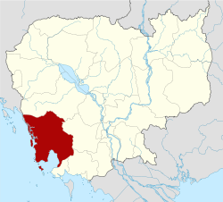
Koh Kong District
Koh Kong District (Khmer: ស្រុកកោះកុង) is a district (srok) of Koh Kong Province, in south-western Cambodia. The southern parts of Koh Kong district is part of Botum Sakor National Park since 1993. It comprise roughly one-third of the district.
| Kaôh Kŏng[2] |
| Khum (Commune) | Phum (Villages) |
| Chrouy Pras | Chrouy Pras, Thmei |
| Kaoh Kapi | Phum Ti Muoy, Phum Ti Pir, Kaoh Sralau |
| Ta Tai Kraom | Kaoh Andaet, Anlong Vak |
| Trapeang Rung | Dei Tumneab, Kaoh Kong Knong, Preaek Angkonh, Trapeang Rung |
|
See also
Notes
- ↑ General Population Census of Cambodia, 1998: Village Gazetteer. National Institute of Statistics. February 2000.
- ↑ Cambodia e-gov "Koh Kong" Accessed June 8, 2008
|
|---|
| | Capital city | | |
|---|
| | Districts | |
|---|
| | Places | |
|---|
|
Coordinates: 11°30′N 103°10′E / 11.500°N 103.167°E / 11.500; 103.167