Ko Chang District
| Ko Chang เกาะช้าง | |
|---|---|
| Amphoe | |
|
Koh Chang | |
 Amphoe location in Trat Province | |
| Coordinates: 12°6′13″N 102°21′7″E / 12.10361°N 102.35194°ECoordinates: 12°6′13″N 102°21′7″E / 12.10361°N 102.35194°E | |
| Country |
|
| Province | Trat |
| Seat | Ko Chang |
| Area | |
| • Total | 217 km2 (84 sq mi) |
| Population (2005) | |
| • Total | 5,356 |
| • Density | 34.6/km2 (90/sq mi) |
| Time zone | THA (UTC+7) |
| Postal code | 23170 |
| Geocode | 2307 |
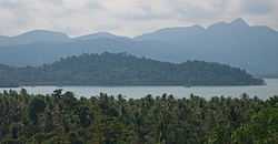
Ko Chang (Thai: เกาะช้าง, pronounced [kɔ̀ʔ tɕʰáːŋ], also Koh Chang) is an amphoe (district) in Trat Province, Thailand. It is located on the Gulf of Thailand's eastern seaboard, 310 km from Bangkok and near the border with Cambodia.
It is the country's third largest island, after Phuket and Ko Samui, and the largest island in the Mu Ko Chang National Park archipelago.
The name means Elephant Island, and comes from the elephant shape of its headland. Despite the presence of elephants on the island, they are not indigenous to the island. At present, there are 9 villages on the island.
It is a mountainous island, with Khao Salak Phet being the highest peak at 743 metres. The island is known for several waterfalls, thriving coral reefs and rainforests. The island has an area of approximately 217 square kilometers.
History
Prior to World War II, Ko Chang was little known. During this period, the few families there made a living growing coconuts and fruit.
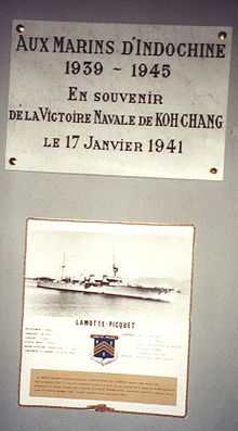
During World War II, when Thailand was occupied by Japanese forces, Ko Chang was the scene of the 1941 Battle of Ko Chang between the Royal Thai Navy and a Vichy French squadron, in which the French won a decisive victory.
Geography
Ko Chang is part of an archipelago of 51 islands, and is approximately 30 km long by 14 km, wide with a total area of 217 km². It is part of the Mu Ko Chang National Park, which covers an area of 650 km², of which 70% is offshore.
The interior of the island is mountainous, covered with tropical rain forest. The highest point is Khao Salak Phet, measuring 743m. There are sandy beaches on the island, dotted with hotels and resorts, in addition to some rocky beaches.
The main settlements on the west coast are around Sai Khao, Hat Kai Mook and Hat Ta Nam, with the village of Bang Bao being situated on the south coast.

Wildlife
Ko Chang is home to populations of the Stump-tailed macaque, the Small Indian Civet, the Small Asian Mongoose, 61 bird species, and a number of snakes and deer.
The Koh Chang Wart Frog (Limnonectes kohchangae) was originally thought to be an endemic species, but has also been found on the mainland.
Administration
The island forms a district (amphoe) in the province of Trat. It was formed on April 30, 1994, when it was split off from Laem Ngop District, at first being classed as a minor district (king amphoe).[1]
Following a decision of the Thai government on May 15, 2007, all of the 81 minor districts were upgraded to full districts.[2] With the publishing in the Royal Gazette on August 24, the upgrade became official.[3]
The district is subdivided into the two subdistricts (tambon) of Ko Chang (Thai: เกาะช้าง), consisting of 4 villages and with a total population of 3,010, and Ko Chang Tai (Thai: เกาะช้างใต้), covering 5 villages and with 2,346 inhabitants.
The district contains the following 9 villages (muban):
- Ban Salak Phet
- Ban Salak Phet Nuea
- Ban Salak Khok
- Ban Chek Bae
- Ban Dan Mai
- Bang Bao
- Ban Khlong Son
- Ban Khlong Phrao
- Ban Khlong Nonsi
Transport
Air
Ko Chang has no airport, with the nearest airport being in Trat on the mainland. Ko Chang Air Taxi offers a seaplane service.
Road
There are two main roads on Ko Chang, running the length of the east and west coasts. Both roads start at Ao Sapparot in the north, near the ferry piers. Shorter roads branch out to Ploytalay Resort and Keereephet, Khlong Nueng and Klong Phu waterfalls.
Songthaew operate on the two main roads, providing both public transport and taxi services.
Motorbike rental and motorbike-taxis are available.
The nearest long distance road transport is at Trat town, from where the 310 km journey to Bangkok takes 5 hours by bus.
Boat
Ferries run from Laem Ngob in Trat town to Ko Chang, connecting with Ao Sapparot pier, Dan Kao pier, and Laem Ngob pier.
Long-tail boats are available for transport to and from nearby islands.
Economy
Ko Chang's income comes largely from tourism, but some traditional livelihoods still exist.
Many of Ko Chang's villages rely on fishing, with Ban Salak Phet (Thai: บ้านสลักเพชร) being the largest and oldest community on Ko Chang, in a sheltered location in the south of the island.
Other fishing villages include Bang Bao (Thai: หมู่บ้านประมงบางเบ้า), at Bang Bao Beach, which consists of houses on stilts built into the sea, and Ban Khlong Son, which also partly relies on rubber plantations.
Ban Dan Mai and Ban Khlong Non Si also have coconut plantations, and orchards of lychee trees. The variety of lychee grown, Silaman 200 years, is believed to be found only on Ko Chang.
Tourism
The first foreign backpackers started arriving on Ko Chang in the mid-1970s, using local fishing boats, when the island was still undeveloped.
In 1982, Ko Chang along with the surrounding area became part of the protected Mu Ko Chang national park, with approximately 85% of the island, together with nearby coral reefs, falling within the park.
It has since become a major tourist destination, both for foreigners and Thais, with a number of tourist resorts being developed.
Despite this, tourism on Ko Chang remains considerably less developed than on Ko Samui or Phuket.
Attractions
The hilly nature of the island provides it with a number of popular waterfalls, including Klong Plu (น้ำตกคลองพลู). It is the only one on the west side of the island, and has an entrance 3 km from Ao Khlong Phrao.
Waterfalls on the east side of the island include Klong Nonsi, Klong Nueng, Khiri Petch which is about 3 kilometers from Salak Petch village, the 5 waterfalls of Kongoi near Bang Bao, and the Thanmayom waterfall near Thanmayom pier.
Ban Salak Phet village has a temple, Wat Salak Phet, built in the reign of King Rama V on his visit to the island.
Bays include Ao Salak Phet, the largest on the island, and Ao Bai Lan (Thai: อ่าวใบลาน).
Ko Chang's beaches include Hat Kai Bae (Thai: หาดไก่แบ้) beach, and Hat Khlong Phrao-Laem Chaiyachet (Thai: หาดคลองพร้าว-แหลมไชยเชษฐ์) beach.
Activities

Popular activities include hiking, mountain biking, canoeing, elephant trekking, diving & snorkeling.
The island also has a number of spas offering various forms of massage, aromatherapy, and reflexology.
Ko Chang is also home to a number of cookery schools.
Events & Festivals
Ko Chang Yutthanavi Day
Ko Chang Yutthanavi Day, which occurs in late January at the Ko Chang Yutthanavi Memorial on Laem Ngop, commemorates the Royal Thai Navy’s engagement against the French at the Battle of Ko Chang on January 17, 1941. There is an exhibition by the Royal Thai Navy, and merit-making and tribute rites are performed.
Health care
Ko Chang has two hospitals, the Bangkok Ko Chang Hospital and Ko Chang Hospital.
Communications
Nationwide Television, satellite TV, cable TV and local TV (Koh Chang Television) channels are available on Ko Chang.
Ko Chang has landline, satellite, and mobile telephone services, and internet connections. There is a Post Office on the island.
References
- ↑ ประกาศกระทรวงมหาดไทย เรื่อง แบ่งเขตท้องที่อำเภอแหลมงอบ จังหวัดตราด ตั้งเป็นกิ่งอำเภอเกาะช้าง (PDF). Royal Gazette (in Thai) 111 (42 ง): 24. May 26, 1994.
- ↑ แถลงผลการประชุม ครม. ประจำวันที่ 15 พ.ค. 2550 (in Thai). Manager Online.
- ↑ พระราชกฤษฎีกาตั้งอำเภอฆ้องชัย...และอำเภอเหล่าเสือโก้ก พ.ศ. ๒๕๕๐ (PDF). Royal Gazette (in Thai) 124 (46 ก): 14–21. August 24, 2007.
External links
 Ko Chang travel guide from Wikivoyage
| ||||||