Knightstown, County Kerry
| Knightstown Baile an Ridire | |
|---|---|
| Village | |
 Knightstown Location in Ireland | |
| Coordinates: 51°55′31″N 10°17′38″W / 51.92532°N 10.293846°WCoordinates: 51°55′31″N 10°17′38″W / 51.92532°N 10.293846°W | |
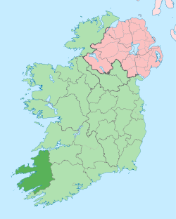
| Country | Ireland |
| Province | Munster |
| County | County Kerry |
| Population (2006)[1] | |
| • Total | 156 |
| Time zone | WET (UTC+0) |
| • Summer (DST) | IST (WEST) (UTC-1) |
| Irish Grid Reference | V422773 |
Knightstown (Irish: Baile an Ridire)[2] is the largest settlement on Valentia Island, County Kerry, in Ireland. It lies within the townland of Farranreagh, at the eastern tip of the island. Knightstown has a population of 156 (CSO 2006).[1]
History
In 1830 Maurice FitzGerald, the 18th Knight of Kerry, commissioned Scottish engineer Alexander Nimmo to draw up plans for a new village. During the 1840s, development began on what was initially known as the New Town of Valentia.[3]

Locality
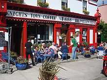
The local RNLI lifeboat station moved to Knightstown in 1869 from Reenard Point and has since been known as the Valentia Lifeboat Station.[4] There is a selection of local coffee shops and bars in the town, as well as Roman Catholic and Church of Ireland (Anglican/Protestant) churches.
Knightstown is also the location of the car ferry connection between Valentia Island and Reenard Point on the mainland.
Knightstown served as a base of operations for the laying of the trans-Atlantic telegraph cable completed in 1866.
See also
References
- ↑ 1.0 1.1 05. Population of Towns ordered by County and size, 2002 and 2006. Census of Ireland 2006 (Report). 1 – Population Classified by Area (Central Statistics Office of Ireland). Knightstown, Valencia Island. Retrieved 26 January 2012.
- ↑ Placenames Database of Ireland
- ↑ "Knightstown" (PDF). West Iveragh Settlements Local Area Plan. Kerry County Council. Retrieved 26 January 2012.
- ↑ RNLI Lifeboat Station History
| ||||||||||||||||||||||